
Castlelaw Hill


Rig And Furrow (Medieval)
Site Name Castlelaw Hill
Classification Rig And Furrow (Medieval)
Canmore ID 277719
Site Number NT26SW 139
NGR NT 2175 6409
NGR Description NT 2162 6409 to 2281 6361
Datum OSGB36 - NGR
Permalink http://canmore.org.uk/site/277719


- Council Midlothian
- Parish Glencorse
- Former Region Lothian
- Former District Midlothian
- Former County Midlothian
NT26SW 139 2162 6409 to 2281 6361
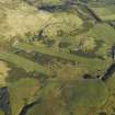
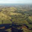
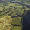
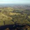
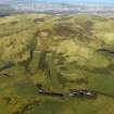
Extensive remains of rig-and-furrow cultivation are visible along the lower part of the S flank of Castlelaw Hill, between Kirk Burn on the NW and the improved fields S of Castlelaw farmsteading (NT26SW 66) on the SE. Much of the rig has been destroyed in recent years and it is perhaps best seen on vertical aerial photographs taken in 1969 by the Ordnance Survey (OS/69/235, 407-8).
Two types of rig are evident; the earlier comprising broad curving rigs, measuring up 10m in breadth and separated by broad furrows, and the later straighter, slightly narrower rigs with a flatter profile and narrow furrows. On the SE bank of the Kirk Burn the curving rigs probably originally ran all the way down-slope to what is now a private road, but they are overlain by a block of straight rig enclosed within a stone-walled field, and now only their upper ends are visible. The rig has been plough-out within the fields immediately S of Castlelaw farmsteading, but a number of truncated rigs can be seen in rough ground between the NW edge of the improved fields and an un-named stream.
Visited by RCAHMS (JRS) 7 June 2005.

