
Castlelaw Hill


Cistern(S) (Period Unassigned), Mound (Period Unassigned)
Site Name Castlelaw Hill
Classification Cistern(S) (Period Unassigned), Mound (Period Unassigned)
Canmore ID 275436
Site Number NT26SW 126
NGR NT 21975 64185
NGR Description NT 21975 64185, NT 22076 64152 and NT 22065 64089
Datum OSGB36 - NGR
Permalink http://canmore.org.uk/site/275436


- Council Midlothian
- Parish Glencorse
- Former Region Lothian
- Former District Midlothian
- Former County Midlothian
NT26SW 126 21975 64185, 22076 64152 and 22065 64089
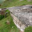
Two cisterns, which formerly supplied water to Castlelaw farmsteading (NT26SW 66), are situated about 100m apart on the SW flank of Castlelaw Hill, about 1km to the WNW of the steading. The NW cistern (CDTA05 70) is set into the steep slope and its sides are banked up with soil. There is an open hatch in the flat concrete roof, and a small brick-built chamber on the SW probably contains an outlet shut-off valve and drain. There is also a smaller chamber adjacent to its SE side. The interior contains water to a depth of about 0.6m.
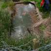
The SE cistern (CDTA05 71), which is also set into the steep slope, comprises an open-topped steel tank, and has a brick-built valve-chamber attached to its S side.
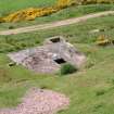
A grass-grown mound of unknown purpose is situated about 50m S of the SE cistern, immediately below the farm track. The mound (CDTA05 68), which measures 19.4m from NNE to SSW by 12.1m transversely and 1m in height, overlies the remains of rig-and-furrow cultivation.
(CDTA05 68, 70-71)
Visited by RCAHMS (JRS), 7 June 2005.

