
Ardmore


Ballast Mound (Period Unknown)(Possible), Fish Trap (Period Unknown)(Possible), Natural Feature (Period Unknown)
Site Name Ardmore
Classification Ballast Mound (Period Unknown)(Possible), Fish Trap (Period Unknown)(Possible), Natural Feature (Period Unknown)
Alternative Name(s) Firth Of Clyde; Inner Clyde Estuary
Canmore ID 274555
Site Number NS37NW 48
NGR NS 3230 7830
Datum OSGB36 - NGR
Permalink http://canmore.org.uk/site/274555


- Council Argyll And Bute
- Parish Cardross (Argyll And Bute)
- Former Region Strathclyde
- Former District Dumbarton
- Former County Dunbartonshire
Field Visit (21 May 2015)
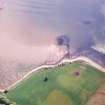
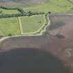
This stony mound, which is situated 120m offshore from Ardmore and has previously been classified as a possible fish-trap or ballast mound, appears to be natural. Its content matches that of the adjacent shoreline: there is another mound 175m to the south which also appears to be natural.
Visited by RCAHMS (AGCH) 21 May 2015.

