
Dunbar, Belhaven


Anti Tank Blocks (20th Century)
Site Name Dunbar, Belhaven
Classification Anti Tank Blocks (20th Century)
Alternative Name(s) Belhaven Bay
Canmore ID 269345
Site Number NT67NE 506
NGR NT 6635 7925
NGR Description NT 663 792 to NT 665 792
Datum OSGB36 - NGR
Permalink http://canmore.org.uk/site/269345


- Council East Lothian
- Parish Dunbar
- Former Region Lothian
- Former District East Lothian
- Former County East Lothian
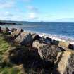
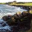
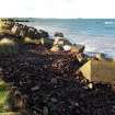
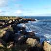
Scattered along the high tide line of the bay on the north side of Winterfield Golf Course are the remains of over 200 concrete anti-tank blocks. They appear to have been re-deposited to form a rough sea wall to prevent erosion of the low sand bank, many of the blocks are broken.
anti-tank cylinders, in two clumps at foot of raised shoreline, seen on 1947 aerial photographs. B174 4057-8 12/8/47.
Site recorded by GUARD during the Coastal Assessment Survey for Historic Scotland, 'The Firth of Forth from Dunbar to the Coast of Fife' 15th February 1996.
Field Visit (27 October 2019)
A field visit was undertaken on 27 October 2019 to photograph what remains of the anti-tank blocks that lie along the high tide line to the east of the small World War Two observation post (NT67NE 162).
Visited by HES Survey and Recording (JRS) 27 October 2019.

