
North Mains


Agricultural Cropmark(S) (Modern)
Site Name North Mains
Classification Agricultural Cropmark(S) (Modern)
Canmore ID 262937
Site Number NT47SW 154
NGR NT 40830 70174
Datum OSGB36 - NGR
Permalink http://canmore.org.uk/site/262937


- Council East Lothian
- Parish Tranent
- Former Region Lothian
- Former District East Lothian
- Former County East Lothian
NT47SW 154 NT 40830 70174
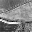
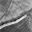
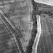
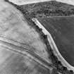
Cropmarks, which may be agricultural in origin, have been recorded on oblique aerial photography (RCAHMSAP 2000) lying on gently sloping ground about 330m W of North Mains.
Information from RCAHMS (KMM) 9 August 2004.

