
Goes Law


Sheep House (19th Century), Sheepfold (19th Century)
Site Name Goes Law
Classification Sheep House (19th Century), Sheepfold (19th Century)
Canmore ID 262715
Site Number NT66SW 39
NGR NT 61445 64078
NGR Description Centre
Datum OSGB36 - NGR
Permalink http://canmore.org.uk/site/262715


- Council East Lothian
- Parish Whittingehame
- Former Region Lothian
- Former District East Lothian
- Former County East Lothian
NT66SW 39 6144 6407
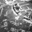
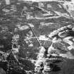
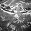
This building, lying on Goes Law about 900m W of Mayshiel, has been recorded on oblique aerial photographs (RCAHMSAP 2000). A thick walled, square structure with an entrance on the SE, it is depicted as roofed on the 1st edition of the OS 6-inch map (Haddingtonshire 1855, sheet 16).
Information from RCAHMS (KMM) 7 April 2004
Note (16 January 2020)
The location, classification and period of this site have been reviewed.

