
Halls


Field Boundary(S) (Period Unassigned)
Site Name Halls
Classification Field Boundary(S) (Period Unassigned)
Canmore ID 260784
Site Number NT67SW 104
NGR NT 64720 72512
Datum OSGB36 - NGR
Permalink http://canmore.org.uk/site/260784


- Council East Lothian
- Parish Spott (East Lothian)
- Former Region Lothian
- Former District East Lothian
- Former County East Lothian
NT67SW 104 NT 64720 72512
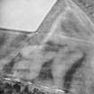
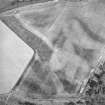
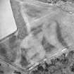
A ploughed down field boundary, which is depicted on the 1st edition of the OS 6-inch map (Haddingtonshire 1855, sheet 11), running NW to SSE has been recorded as cropmarks on oblique aerial photography (RCAHMSAP 2000). The boundary overlies an earlier ditched field boundary which runs roughly WSW to ESE and there is a further ditch, also recorded as a cropmark, to the NW.
Information from RCAHMS (KMM) 23 June 2004

