 |
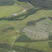
On-line Digital Images |
DP 142843 |
RCAHMS Aerial Photography Digital |
Oblique aerial view of the pig farm at the Invernahavon battle site, looking WNW. |
25/7/2012 |
Item Level |
|
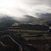 |
On-line Digital Images |
DP 189364 |
RCAHMS Aerial Photography Digital |
General oblique aerial view of the Invernahavon battlesite at the confluence of the Spey and Truim, looking SW. |
19/2/2014 |
Item Level |
|
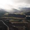 |
On-line Digital Images |
DP 189365 |
RCAHMS Aerial Photography Digital |
General oblique aerial view of the Invernahavon battlesite at the confluence of the Spey and Truim, looking SW. |
19/2/2014 |
Item Level |
|
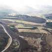 |
On-line Digital Images |
DP 189366 |
RCAHMS Aerial Photography Digital |
General oblique aerial view of the Invernahavon battlesite at the confluence of the Spey and Truim, looking SW. |
19/2/2014 |
Item Level |
|
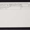 |
On-line Digital Images |
SC 2388135 |
Records of the Ordnance Survey, Southampton, Hampshire, England |
Invernahavon, NN69NE 2, Ordnance Survey index card, Recto |
1958 |
Item Level |
|
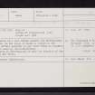 |
On-line Digital Images |
SC 2388136 |
Records of the Ordnance Survey, Southampton, Hampshire, England |
Invernahavon, NN69NE 2, Ordnance Survey index card, Recto |
1958 |
Item Level |
|
|
All Other |
551 166/1/1 |
Records of the Ordnance Survey, Southampton, Hampshire, England |
Archaeological site card index ('495' cards) |
1947 |
Sub-Group Level |
|


