
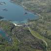
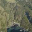
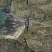
Loch Nan Uamh Viaduct


Railway Viaduct (20th Century)
Site Name Loch Nan Uamh Viaduct
Classification Railway Viaduct (20th Century)
Alternative Name(s) Gleann Mama; Allt A' Mama; Beasdale Burn; Glen Beasdale; Lochailort
Canmore ID 22716
Site Number NM78SW 4
NGR NM 72881 84115
Datum OSGB36 - NGR
Permalink http://canmore.org.uk/site/22716


- Council Highland
- Parish Arisaig And Moidart
- Former Region Highland
- Former District Lochaber
- Former County Inverness-shire
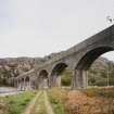
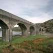
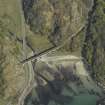
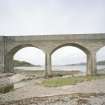
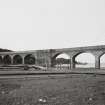
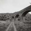
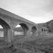
In 1897-1901, making pioneering use of mass concrete, engineers Simpson & Wilson produced for the North British Railway's 40 mile West Highland Line extension a series of bridges, culverts, platforms, retaining walls, 11 tunnels and six viaducts, which have defied corrosion. This monument to concrete engineering earned for its contractor Robert McAlpine the nickname 'Concrete Bob'. Viaducts: six-arched at Arnabol, eight-arched at Loch Nam Uamh (four each side of a great central concrete pylon); three-arched (with rusticated voussoirs) crossing the Brunery Burn at Larachmor and, most daring of all, a central span leaping 12 7.5 ft over a steep gully at Borrodale, twice the span of any existing arch at the time.
Taken from "Western Seaboard: An Illustrated Architectural Guide", by Mary Miers, 2008. Published by the Rutland Press http://www.rias.org.uk

NM78SW 4 72881 84115
For group of short railway tunnels to the N of this viaduct, see NM78SW 20-3.
Loch nan Uamh Viaduct [NAT]
OS 1:10,000 map, 1973.
West Highland Extension; North British Railway. Opened 1901.
(Undated) information in NMRS.
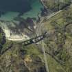
(Location cited as NM 729 841). Loch nan Uamh Viaduct, completed 1901 by the West Highland Extension Rly. An 8-span mass concrete viaduct with arches of the standard WHER 50ft (15.2m) span.
J R Hume 1977.
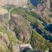
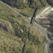
This viaduct was built to carry the West Highland (Extension) railway across the valley of the Beasdale Burn at the head of Loch nan Uamh. The line was opened to traffic on 1 April 1901, absorbed into the North British Rly on 31 December 1908, and remains in use.
M Smith 1994.
This RCAHMS photographic survey was conducted in order to enhance and augments the National Monuments Scotland holdings.
In 2001, specially commissioned scans of the bridge confirmed the existence within the fabric of the large central pier of a horse and cart, which had fallen into the cavity of the pier during construction. Until this time, it had not been certain at which bridge this accident had occurred.
Visited by RCAHMS (MKO), July 1997.
The location assigned to this record defines the apparent centre of the structure. The available map evidence indicates that it extends from NM c. 72880 84131 to NM c. 72883 84110.
Information from RCAHMS (RJCM), 11 May 2006.
Publication Account (2007)
West Highland Extension Railway
(Institute Civil Engineers Historic Engineering Works no. HEW 0084/02)
The West Highland Railway, originally worked by the North British Railway, is one of the world’s most scenic railways. It could also be said to be the last considerable piece of railway building in Britain, its single track
snaking north-west 140 miles from Craigendoran on the Clyde to the fishing port of Mallaig. The 100-mile Craigendoran to Fort William section was begun in 1889 and opened in 1894, and the 40-mile Mallaig extension, was begun in 1897 and completed in 1901.
The Craigendoran–Fort William section was engineered by Formans & McCall, and the main contractor was Lucas & Aird, a prominent London firm whose driving force was John Aird, an MP of crofting stock. The summit is at Corrour, 1345 ft above sea level on Rannoch Moor. The
methods of crossing the waterlogged moor on brushwood were developed from traditional experience.
Spectacular viaducts include Glen Falloch (NN 3170 2020) 145 ft high, and two in the great Horseshoe Curve above Tyndrum (NN 3350 3620).
Financially the line fared precariously during construction and had to be rescued on one occasion by a director, J. H. Renton, using his private fortune. In gratitude his head was sculpted on a massive rock at Rannoch Station by navvies using only the tools of their trade. It is still there.
The Mallaig extension, built to support the fish trade, struggles westwards through inhospitable mountainous country and winding inlets of the sea. The line has gradigradients as steep as 1 in 40 and curves of 12 chains radius (800 ft) both of which impose drastic limits on speed of trains. Much of its length is on embankment, bridges or hewn out of the living rock in cuttings and tunnels. Today the line is a major tourist attraction with many
steam ‘specials’ in addition to regular services. In engineering terms the line is renowned for the early use of mass concrete in bridge construction. The structures were originally planned to be constructed in masonry, but
the local rock ( mica schist) was too hard and difficult to dress. Concrete offered a cheap alternative solution. In consequence of his usage of this material Robert McAlpine became known as ‘Concrete Bob’. The line’s most notable elements are Glenfinnan and Loch nan Uamh viaducts and Borrodale Arch. The railway was designed by Simpson & Wilson, consulting engineers, and the contractor was Robert McAlpine & Co.
R Paxton and J Shipway, 2007.
Reproduced from 'Civil Engineering heritage: Scotland - Highlands and Islands' with kind permission from Thomas Telford Publishers.
Publication Account (2007)
Loch nan Uamh Viaduct
(Institute Civil Engineers Historic Engineering Works no. HEW 0021/02)
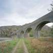
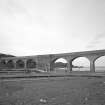
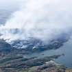
The scenic location of this viaduct, at the foot of a rocky mountainside and bridging an inlet to the sea, has been described as Wagnerian. It has eight concrete arches of the standard West Highland Railway span of 50 ft arranged in two four-arch groups on either side of a 50 ft wide central pier. The reason for this unusual arrangement in preference to the more obvious and attractive arrangement of nine arches is not known.
In 2000, Professor Paxton and Radar World, commissioned by Sir Robert McAlpine Ltd, developed an innovative radar imaging technique which penetrated the 9 ft thick walls of this pier into its infilled cavity and identified the vertically positioned remains of a McAlpine horse and cart (behind the white spot in the view) which had accidentally fallen into the cavity a century earlier.
R Paxton and J Shipway, 2007.
Reproduced from 'Civil Engineering heritage: Scotland - Highlands and Islands' with kind permission from Thomas Telford Publishers.
Note (July 2008)
Confirming a West Highland Railway viaduct legend by Professor Roland Paxton MBE
In 1984, when recording the 21-arch, mass-conctrete, Glenfinnan Viaduct for the Institution of Civil Engineers' Panel for Historic Engindeering Works, the legend of a Robert McAlpine horse and cart being buried in a pier after an accident during construction in c.1898 was addressed by Prof. Roland Paxton.
In 1987, Prof. Paxton and colleagues invetstigated the viaduct by inserting a camera into cavities within the piers in the viaduct big enough to hold a horse and cart. There were two: a fish-eye lens camera mounted of a long pole was inserted via inspection holes into each pier cavity and photographs taken at 45 degree intervals i.e. from 0 degrees (vertical) clockwise to 315 degrees. Dissappointingly, the images did not show any evidence of a horse and cart, although it was on interest that some upper timberwork left in place after construction still remained.
The Professor then heard from Dr Jim Shipway, great grandson of the designer, Alexander Simpson, that Ewen Macmillan of Borrowdale remembered local hearsay in his father's time that the accident had occurred at Loch-nan-Uamh viaduct. The central pier of Loch-nan-Uamh viaduct was the only one large enough to have accommodated the remains of a horse and cart. In 2001, eleven hours of intensive site work involving transmission of radio waves through walls up to 9 feet thick revealed the remains of the horse, propped vertically against the east wall of the cavity above the wreck of the cart. This seems consistent with the horse having been dragged down into the cavity from about track bed level as the viaduct was nearing completion by a loaded stone cart.
Information from Prof. R Paxton, July 2008.

