
Baliscate, Mull


Standing Stone(S) (Prehistoric)
Site Name Baliscate, Mull
Classification Standing Stone(S) (Prehistoric)
Alternative Name(s) Tobermory
Canmore ID 22086
Site Number NM45SE 1
NGR NM 4996 5413
Datum OSGB36 - NGR
Permalink http://canmore.org.uk/site/22086


- Council Argyll And Bute
- Parish Kilninian And Kilmore
- Former Region Strathclyde
- Former District Argyll And Bute
- Former County Argyll
NM45SE 1 4996 5413.
(NM 4996 5413) Standing Stones (NR)
OS 1:10000 map (1976)
Stone Circle (NR) (Remains of)
OS 6" map (1900)
Listed by Burl as a stone circle 'of uncertain status, including misidentified sites'.
H A W Burl 1977; A Thom 1967
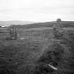
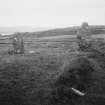
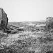
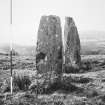
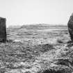
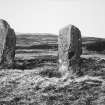
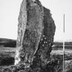
Standing Stones, Balliscate: In moorland 390m SW of Balliscate, three standing stones of basalt have been erected in an approximately straight line running N and S. The northern stone (A on plan), 1.7m in height and 0.65m by 0.6m at the base, is a straight-sided monolith with a flattish top. Stone B is prone, half-embedded in peat, and is 2.8m long by 0.7m broad and 0.4m thick. The tallest of the stones (C) stands within a ruined turf-and-stone bank and measures 2.6m in height, 1.1m in breadth and 0.8m in thickness; it is an irregular slab, which expands above the base before narrowing to a pointed top.
J W Judd 1875; RCAHMS 1980, visited 1972.
When seen in April 1972, these three stones were in a similar condition to that described by the RCAHMS. There was no evidence to suggest that there had ever been a stone circle at this site.
Surveyed at 1:2500.
Visited by OS (DWR) 21 April 1972.
NM 4996 5413 Before excavation, this site comprised two standing stones with a recumbent central stone and was recorded as a possible three-stone row. The initial stages of excavation revealed the stump of a fourth, smaller, stone surrounded by packing stones just beneath the peat. The top of this stone has been broken off, perhaps deliberately, at some point in the more recent past and remains unlocated. This was to the N of and in direct alignment with the two standing stones. Immediately to the W of its packing, cut into the prehistoric ground surface, a very small deposit of cremated bone was uncovered beneath a large lump of charcoal.
The socket of the recumbent stone was discovered sharing the same alignment, and was approximately equidistant between the two remaining standing stones. At some point during prehistory it either collapsed or was deliberately overthrown (as had happened nearby at Ardnacross, a double stone row), and came to rest in the position it occupies today. The substantial socket stones were scattered and the socket (not fully excavated) filled up with darker earth and peat.
The ground surface underneath the peat consisted of a layer of waterlogged clay silt that contained numerous small degraded stones, along with frequent specks and patches of charcoal and reddish clay. Areas of this surface had either been burnt or burning had occurred nearby, although it was unclear if this practice was deliberate or incidental. This layer also contained one piece of crudely worked flint and several pieces of degraded quartz, neither of which are local in origin. The site can now confidently be identified as a four-stone row, and it is hoped that radiocarbon dates can be obtained from the cremated bone.
Sponsors: University of Manchester - School of Arts, Histories and Cultures and Student Enterprise Fund.
J Wright 2004
Field Visit (28 July 1942)
This site was included within the RCAHMS Emergency Survey (1942-3), an unpublished rescue project. Site descriptions, organised by county, vary from short notes to lengthy and full descriptions and are available to view online with contemporary sketches and photographs. The original typescripts, manuscripts, notebooks and photographs can also be consulted in the RCAHMS Search Room.
Information from RCAHMS (GFG) 10 December 2014.
Laser Scanning (25 July 2016 - 27 July 2016)
AOC Archaeology Group were commissioned by Forestry Commission Scotland to undertake a laser scan survey of selected elements of three Stone Rows on Mull. The Standing Stones at Baliscate; Cnoc Fada and Maol Mor were surveyed. The survey was undertaken for conservation management purposes.
Information from OASIS ID: aocarcha1-267118 (J Humble) 2016

