
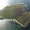
Eynhallow Monastery


Architectural Fragment(S) (Medieval)(Possible), Church (12th Century), Monastery (Medieval), Settlement (Medieval) - (Post Medieval)(Possible)
Site Name Eynhallow Monastery
Classification Architectural Fragment(S) (Medieval)(Possible), Church (12th Century), Monastery (Medieval), Settlement (Medieval) - (Post Medieval)(Possible)
Alternative Name(s) Enhallow
Canmore ID 2170
Site Number HY32NE 2
NGR HY 35902 28822
Datum OSGB36 - NGR
Permalink http://canmore.org.uk/site/2170


First 100 images shown. See the Collections panel (below) for a link to all digital images.
- Council Orkney Islands
- Parish Rousay And Egilsay
- Former Region Orkney Islands Area
- Former District Orkney
- Former County Orkney
Antiquarian Observation (1846 - 1870)
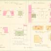
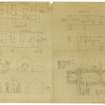
Plans and drawings by Sir Henry Dryden in folio titled 'Churches in Orkney and Shetland', dated 1846, 1851-2, 1855, 1863, 1866 and 1870 in the Society of Antiquaries of Scotland Collection.
Field Visit (11 June 1967)
Eynhallow Monastery is as described and planned by the RCAHM (1946). Surveyed at 1:10,000 (by Field Surveyor).
Visited by OS (NKB) 11 June 1967
Field Visit (August 1982)
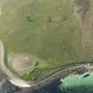
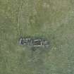
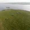
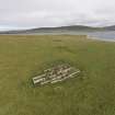
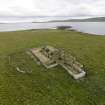
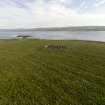
Eynhallow monastery HY 3590 2883 HY32NE 2
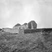
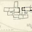
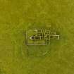
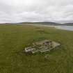
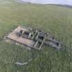
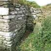
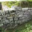
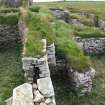
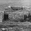
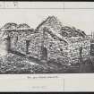
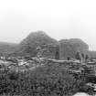
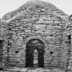
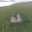
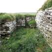
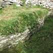
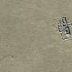
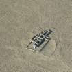
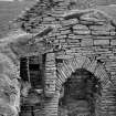
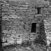
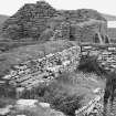
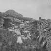
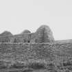
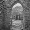
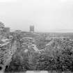
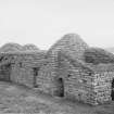
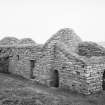
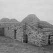
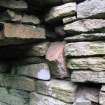
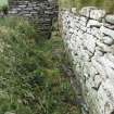
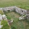
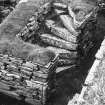
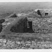
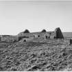
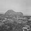
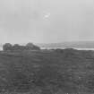
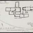
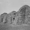
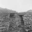
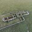
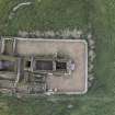
The shell of a quite grandly conceived but curiously executed church consisting of nave and chancel with a western 'porch', adjoining a complex of buildings which have been variously claimed to be medieval and monastic, or to be post-medieval and domestic. While both church and buildings have undergone numerous and drastic alterations in recent centuries, it is likely that this complex essentially represents a monastic layout, possibly originating as a Benedictine foundation of the second quarter of the twelfth century, and evidently extinct as a religious house well before the sixteenth century. The buildings are in guardianship but in recent years have become overgrown with nettles and infested by fulmars.
RCAHMS 1982, visited August 1982
(Sir Henry Dryden's drawings in NMRS; Muir 1885, 68-9 and 252-4; MacGibbon and Ross 1896-7, i, 116-22; Craven 1901, 16; Dietrichson 1906, 126-33 with plan (Norwegian text), 36-43 (separately paginated English text, full translation); Mooney 1933; Taylor 1938, 401; RCAHMS 1946, ii, pp. 230-4, No. 613; Mooney 1949; Guamundsson, Orkneyinga Saga, footnote, 269; Lamb 1973; Cowan and Easson 1976, 61-2; OR 551)
Desk Based Assessment (21 January 1983)
HY32NE 2 35902 28822
(HY 3590 2883) Church (NAT) (remains of)
OS 1:10,000 map, 1977.
Eynhallow Monastery: The shell of a quite grandly conceived but curiously executed church consisting of nave and chancel with a western 'porch', adjoining a complex of buildings which have been variously claimed to be medieval and monastic, or to be post-medieval and domestic. While both church and buildings have undergone numerous and drastic alterations in recent centuries, it is likely that this complex essentially represents a monastic layout, possibly originating as a Benedictine foundation of the second quarter of the 12th century, and evidently extinct as a religious house well before the 16th century. The buildings have become overgrown with nettles. (See also HY33SE 17.01)
Information from OS (IF) 21 January 1983
Sources: T S Muir 1885; MacGibbon and Ross 1896; L Dietrichson and J Meyer 1906; J Mooney 1933; RCAHMS 1946; J Mooney 1949; I B Cowan and D E Easson 1976; RCAHMS 1982.
Publication Account (1996)
The original identity of this most interesting group of buildings was entirely unsuspected until the mid 19th century. They had been in domestic use as houses since the 16th century until, in 1851, an epidemic of fever led to their evacuation; in order to make the buildings uninhabitable, the roofs were removed and in the process it was realised that part of the complex was an old church. The site was not properly cleared of debris until 1897, then the celebrated architect of Mclsetter (no. 12), Professor W R Lethaby, was there to examine and report on the structure.
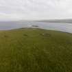
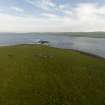
The name Eynhallow means Holy Isle from Old Norse, Eyin Helga, which suggests that there may have been a small Celtic monastery here even before the 12th-century church was built. Its monastic status at the latter period is implied by the story in Orkneyinga Saga (chap. 97) of the kidnapping of Olaf, the son of Svein Asleifarson of Gairsay and foster-son of Kolbein Hruga of Wyre; the kidnappers knew where to find Olaf on Eynhallow, and it is most likely that the boy was there to be educated in the monastery.
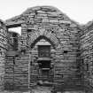
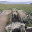
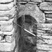
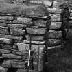
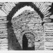
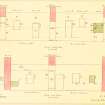
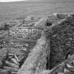
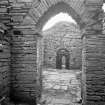
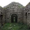
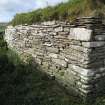
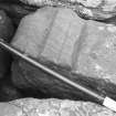
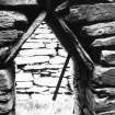
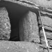
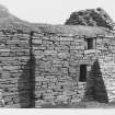
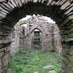
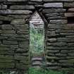
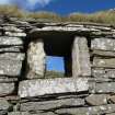
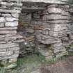
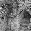
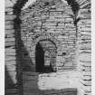
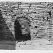
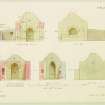
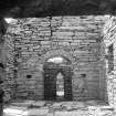
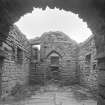
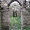
The church was built to a relatively sophisticated design: a rectangular nave opens at the east end into a rectangular chancel and at the west end into a substantial square porch (it is even possible that the latter represents the lower part of a tower). Although the walls both of the church and the adjacent buildings survive to roof-level, it is very difficult to analyse the architectural sequences present, because of additions and modifications relating to the domestic use of the site from the 16th century onwards, though the latter are interesting in themselves. The archaic, even primitive, character of various of the doorways and archways of the church is unmistakeable and somewhat at variance with the grand layout. The west and north doorways into the porch are original and very narrow (0.46m): the triangular arch of the west door is formed by two inclined slabs, while the round arch of the north door is cut into a single block of red freestone with a crude moulding on its external face. Entry into the nave is through a semi-circular arch of split slabs, while the arch between nave and chancel is a most ingenious rendering of the pointed arch that became fashionable in the 12th century. The springers and keystone are triangular blocks carved out of red freestone, allowing the rest of the arch to consist of the usual split slabs, a most economical way to achieve a pointed arch without mortar and with the minimum of dressed stone.
Information from ‘Exploring Scotland’s Heritage: Orkney’, (1996).
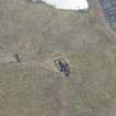
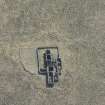
Geophysical Survey (25 April 2007 - 29 April 2007)
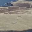
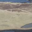
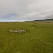
HY 36041 29076 A desk-based assessment and walkover survey of the island of Eynhallow was undertaken in April 2007. In addition, geophysical survey was conducted at two sites. Approximately 3600m2 of gradiometry was conducted over a suspected burnt mound [HY32NE 29], which revealed several diagnostic crescent-shaped concentrations of highly fired material. Approximately 1ha of gradiometry was also undertaken around the monastic site [HY32NE 2]. Although partially obscured by an igneous dyke crossing the survey area, there was clear evidence of settlement corresponding to the mound on which the monastic site sits and some of the anomalies also hint at features predating the extant structures. Anomalies were also noted that confirmed the
existence of rig and furrow cultivation surrounding the site.
Report to be deposited with the Orkney SMR and RCAHMS.
Funder: Hunter Archaeological Trust, Viking Society for Northern Research, Orkney Archaeological Trust, Orkney College Geophysics Unit.
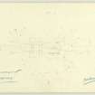
Measured Survey (13 August 2015)
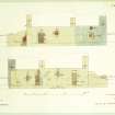
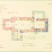
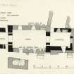
RCAHMS surveyed the church at Eynhallow on 13 August 2015 with plane-table, producing a plan of the interior of the church at a scale of 1:50.
Fabric Recording (2015)
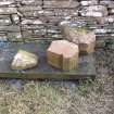
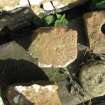
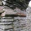
HY 35900 28820 (Canmore ID: 2170) The Scottish Medieval Castles and Chapels C14 Project (SMCCCP) is a nationwide funded buildings archaeology project investigating the archaeological potential of building materials surviving within upstanding medieval structures. The SMCCCP combines the survey and analysis of medieval buildings and environments, with the analysis and radiocarbon dating of surviving building materials. The project seeks to constrain building chronologies, and investigate the technical conversion and palaeoenvironmental potential of source materials.
The upstanding masonry of the church on Eynhallow was investigated over a four day period in 2015. The building was found to display a range of phase-specific constructional techniques and materials, including various maerl-lime (produced from the burning of coralline algae rhodoliths), limestone-lime and clay mortars, and these enabled much of its medieval and later development to be re-interpreted on site. Various loose mortar and environmental samples were also taken for further laboratory based analysis. Significant discoveries included: the remains of an earlier, primary, square chancel beneath the walls of the upstanding building; the remains of a medieval doorway in the SW of the nave, and the remains of an opening in the upper W wall of the nave which suggests the eastern cell is indeed the remains of a tower.
These discoveries, and research at other broadly contemporary sites in Orkney, suggest that the church on Eynhallow is not the constructionally idiosyncratic structure that has previously been suggested. The building displays a range of masonry techniques seen quite widely throughout the region in the Late Norse period, whilst the rebuilding of a 12th-century square chancel on a longer plan in the later medieval period conforms to similar developments seen in many churches throughout NW Europe. Moreover, the form of the openings in the W tower suggest that physical and visual access from the nave was privileged, and this also conforms to contemporary practice in insular western towers elsewhere; this is a feature usually associated with the display of burial. The other openings in the other walls of the W tower, however, are more unusual and demanding of explanation, as these also allowed some form of access to the western cell from outside the church and vice-versa. This focus on the display of burial from various perspectives, the
sound of the bells, the island's geographical position midway between Egilsay and Birsay, and various other strands of evidence, suggest this site may be the focus of a ritual associated with the Magnus pilgrimage route.
This work on the church was undertaken in conjunction with an analysis of the upstanding fabric of the adjacent domestic complex and a walkover survey of the wider island made by George Geddes (RCAHMS), and a more holistic joint publication of the medieval and later archaeology of the island is intended.
Archive: National Record of the Historic Environment (NRHE) intended
Funder: Historic Environment Scotland
Mark Thacker – University of Edinburgh
(Source: DES, Volume 16)

