
Iona Monastery, St Columba's Shrine


Shrine (Early Medieval) - (Medieval)
Site Name Iona Monastery, St Columba's Shrine
Classification Shrine (Early Medieval) - (Medieval)
Canmore ID 21652
Site Number NM22SE 4.03
NGR NM 28655 24513
Datum OSGB36 - NGR
Permalink http://canmore.org.uk/site/21652


- Council Argyll And Bute
- Parish Kilfinichen And Kilvickeon
- Former Region Strathclyde
- Former District Argyll And Bute
- Former County Argyll
NM22SE 4.3 2861 2450
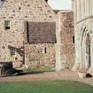
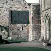
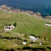
(NM 2866 2450) A tiny building, now only a yard or so high partially underlies and projects to the west and just north of the nave of the Medieval abbey church.
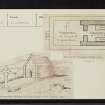
It measures 10'5" E-W by 7'5" N-S within the 1'10" thick walls of well-built squared stones. Buttresses or antae project to the west, and a doorway slightly less than 2' wide with square parallel jambs pierces the centre of the west gable. No signs of a window survive. The line of a high pitched roof was formerly visible against the later wall 'just the line and angle that one would expect in an early Celtic oratory, many of which remain intact in Ireland'.
In the centre of the east wall stood the altar with on each side a coffin, 6'9" by 1'8" by 14" deep, formed of slabs of schisty stone. The lids are missing.
To the west of this 'oratory' there extends a 'narthex' or oblong area 13'4" by 10'8" enclosed on three sides by a wall 18" high and 21" thick. To the west of this enclosure, the walls of which may never have been any higher, stands the Cross of St John (NM22SE 4.05).
This is the 'cell' mentioned by Martin as containing the tomb of Columba. Waddell believes, in spite of Adamnan's testimony to the contrary, that this was a stone church built in Columba's lifetime and that the coffin to the south of the altar was his tomb, and that to the north the tomb of St Blathmac, his successor.
Skene apparently considered this to be the main church of the first stone monastery and the coffin on the south side was the receptacle for the shrine in which the 'Matra' was placed for veneration.
M Martin 1695 ; J J Waddell 1941.
'The "shrine" presents numerous problems. It has been rebuilt as a chapel, and below the floor are two graves which have been claimed as those of St Columba and a companion. This is not documented in any way, the graves are not like any other known shrines of the Celtic period and, posing the most difficult problem, they seem never to have been incorporated into a church or chapel as happenned to almost all other known shrines of the period. Perhaps the most one can say now is that the present structure may perpetuate some medieval arrangement which linked the spot to the monastic founder'.
R Reece, undated
An ancient burial ground lies between St John's Cross and the 'oratory'.
A Ritchie and E Ritchie 1934
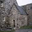
This building has been restored and is now in use as a small chapel, known as "St Columba's Shrine". No trace of the coffins survives.
Visited by OS (RD) 9 June 1972.
Field Visit (September 1980)
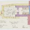
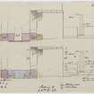
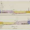
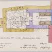
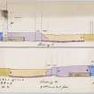
The position of three major crosses of 8th- or 9th-century date, St John's, St Martin's and St Matthew's (RCAHMS 1982 No. 6, 82-4), all apparently in situ, strongly suggests that the ecclesiastical focus of the early monastery was on the site of the medieval church, and immediately to the w of it. Some of the inadequately-recorded foundations discovered below the nave early in the present century may have formed part of a stone church of the Early Christian period, but the evidence is extremely uncertain (ibid, p. 109). Some 3m NW of the NW angle of the nave, however, and 4.9m E of St John's Cross, there is a small chapel, now rebuilt and called 'St Columba's Shrine', which appears to belong to that period. It measures 3.2m from E to w by 2.15m transversely at the E end and 2.3m at the W end, within walls 0.55m in thickness. When the area was cleared of overlying debris during Anderson's restoration of 1874-5, the walls were found standing to a uniform height of about 1 m, but at that time the E end of the S wall and the S end of the E wall were heightened , presumably as buttresses for the late medieval tower at the NW angle of the nave (47) (ibid, p. 111). In 1962 the building was restored by the Iona Community for use as a chapel, to the designs of I G Lindsay.
The original masonry of the chapel comprised mainly dark Torridonian flagstone of local origin, whereas in both periods of restoration a considerable amount of quarried granite was also used. The S wall, whose outer face was investigated during excavation in 1976 (48), was constructed upon a trench-built foundation of rounded granite and other boulders, probably derived from the local drift deposits, incorporating a vertical slab of mica-schist 1.6m from the w end; this footing was levelled off with a course of mica-schist and granite slabs about 0.4m below present ground-level. The foundation-trench had cut through a number of earlier post-holes and other features (p. 41), but owing to disturbance by later activity, such as the laying of medieval paving, no stratigraphic dating of the building was possible, except that it preceded the late medieval angle tower (49). In the w wall of the chapel there is a doorway 0.54m in width, having vertical unrebated jambs of Carsaig sandstone. The side-walls extended to the w to form buttresses or antae, 0.55m in both length and width, but this feature was not repeated during the restoration of the chapel. The antae were faced with sandstone ashlar, integral with the masonry of the side-walls, and built into the SW one, probably in the 19th century, there is a moulded fragment which may be of Early Christian date (No. 6, 107). The E wall of the chapel, which was incorporated into the w wall of the cloister, has been rebuilt, probably more than once, but at its junction with the NW angle-tower of the nave, and at a height of about 1·5 m above the cloister pavement, there is a projecting block of sandstone which may have formed part of the SE anta. The building contains two slab-lined cists, probably of medieval date (p. 137).
The plan of this diminutive building, with its projecting antae and a length to breadth proportion of almost exactly three to two, closely resembles those of some of the earliest Irish stone churches. The dating of these structures is uncertain, and this example, with its sandstone dressings, is unlikely to be earlier than the 9th or 10th century (50). The recent excavation has provided no evidence either for or against the supposition that the stone building replaced an earlier timber oratory. Its modern designation, 'St Columba's Shrine', is an evident misnomer, since the shrine in which Columba's remains were placed in the 8th century (p. 47) almost certainly stood in the principal church of the monastery. The modern name, however, is derived from a much older tradition, recorded in the late 17th century, that this was the site of the saint's tomb or 'monument' (51). In view of the uncertain date of origin of Reilig Odhráin (p. 13), and the well-attested medieval veneration for the original burial-places of saints, even after the translation of their remains (52), this tradition merits serious consideration. The building has also been identified, probably correctly, with the 'small church of Columcille' mentioned in a saga account of the Hebridean expedition of the Norwegian king, Magnus Barelegs, in 1098 (p. 48). Tradition held that 'the king did not go in, but closed the door again, and locked it, and said that none should be so daring as to go into that church; and thenceforward it has been so done' (53).
RCAHMS 1982, visited September 1980
(47) Dryden MS 7; photographs in NMRS.
(48) PSAS, 108 (1976-7), 230-2, 238.
(49) Ibid., 232.
(50) Cf. Leask , Irish Churches, 1, 49 and passim. For the problems of dating these buildings, see Harbison, P, in Med. Arch., 14 (1970), 34-59; Hughes and Hamlin, Early Irish Church, 57-67.
(51) Sacheverell, Voyage, 132-3; Geog. Coll., 2, 216; Martin, Western Islands, 287-8. Cf. PSAS, 11 (1874-5), 341-6.
(52) Cf. the sequence of structures below St Swithun's Chapel, Winchester (Arch. J. 114 (1957), 28-68; Ant. J., 48 (1968), 275-80; 50 (1970), 318-20) and the commemoration of the original tombs of St Thomas Becket in the crypt of Canterbury Cathedral and of St Kentigern in the lower church at Glasgow Cathedral (Stones, E L G, in Innes Review, 18 (1967), 88-92).
(53) Skene, Celtic Scotland, 2,354; PSAS, II (1874-6),345; Heimskringla, quoted in Anderson, Early Sources, 2, 107-9.
External Reference (28 October 2011)
Scheduled as element within 'The monument known as St Mary's Abbey, Iona, monastic settlement [comprising] the remains of the large early historic monastic settlement founded by St Columba in AD 563, St Martin's Cross, and parts of medieval buildings associated with the Benedictine Abbey of St Mary founded around AD 1200.'
Information from Historic Scotland, scheduling document dated 28 October 2011.
Watching Brief (14 November 2012 - 23 November 2012)
NM 2865 2452 Columba’s Shrine. A trench measuring 3.80m x 1.98m was excavated to record the surviving paved surface, previously recorded in this small ruinous building, currently covered by modern infill. This surface included a recumbent cross slab, subsequently lifted for conservation and display. The excavation confirmed that the paving was intact and generally set within a clay-rich bedding deposit. There was some evidence of another, possibly earlier, fragmentary paved surface to the N and S of the cross slab. The W doorway and W-facing elevation were also recorded.
Sponsor: Historic Scotland
D Murray 2013
Kirkdale Archaeology
OASIS Id: kirkdale1-311432
Excavation (20 February 2013 - 11 April 2013)
NM 2856 2448 Signage, drainage and hard standing. Only two drainage trenches, running parallel to, and E of, the boundary dyke at the SW entrance, reached greater than 200mm. They measured 5.25m x 550mm and 8.50m x 400mm. Both were dug to a depth of c500mm and revealed a deep deposit of cultivated soils, below modern landscaping and services. The cultivated soils were c200mm deep, sealing a series of truncated cuts, associated with a crude metalled surface (unexcavated). The cultivation horizon is probably 19th- to early 20th-century in date.
Sponsor: Historic Scotland
D Murray 2013
Kirkdale Archaeology

