Coll, Dun Foulag
Natural Feature (Period Unknown)
Site Name Coll, Dun Foulag
Classification Natural Feature (Period Unknown)
Canmore ID 21572
Site Number NM15NE 6
NGR NM 1750 5908
Datum OSGB36 - NGR
Permalink http://canmore.org.uk/site/21572
- Council Argyll And Bute
- Parish Coll
- Former Region Strathclyde
- Former District Argyll And Bute
- Former County Argyll
NM15NE 6 1750 5908.
Dun Foulag is situated 1200 yds NE of An Caisteal, on an isolated rock of no great size, on the shore near the S point of Bagh Craimneach. Apart from its traditional name, and the existence of slight walls to the SE, where there are also many fallen stones at the base, this dun is not well-marked, though by no means of doubtful character. The rock is most abrupt, with a single access to the E.
E Beveridge 1903.
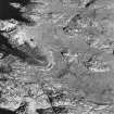
Dun Foulag, at NM 1750 5908, is a natural rocky knoll with no trace of antiquity. The 'slight walls' at its base in the SE are modern and the 'fallen stones' are beach stones.
Visited by OS (R L) 20 June 1972.


