
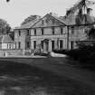
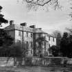
Smeaton House


Country House (Period Unassigned)
Site Name Smeaton House
Classification Country House (Period Unassigned)
Alternative Name(s) Smeaton Hepburn
Canmore ID 209979
Site Number NT57NE 185
NGR NT 59304 78601
Datum OSGB36 - NGR
Permalink http://canmore.org.uk/site/209979


- Council East Lothian
- Parish Prestonkirk
- Former Region Lothian
- Former District East Lothian
- Former County East Lothian
NT57NE 185.00 59304 78601 Smeaton House
The house is depicted on the OS 1:2500 scale map (Haddingtonshire, Sheet VI, 9, 1907) and has since been demolished. Information from RCAHMS (S.C.), Feb. 2002.
NT57NE 37 5943 7860 Garden Walls
NT57NE 38 5931 7785 Gate-Lodge
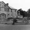
NT57NE 185.01 59361 78736 Farmsteading, East Range
NT57NE 185.02 59397 78767 Farmsteading, East Range, Gardener's Cottage
NT57NE 185.00 59304 78601 Smeaton House
NMRS REFERENCE:
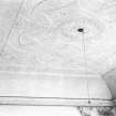
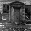
Was sold to contractors for partial demolition in 1948, and measured just as this was being commenced. Contractors from Tranent.
NMRS Measured drawing notes by S Tyrowicz - manuscripts.
EXTERNAL REFERENCE:
National Library
'Castles & Mansions of the Lothians' by Small - article and photograph.
Photographic Survey (1948)
Photographs of Smeaton House, East Lothian, by the National Buildings Record Scottish Council in 1948, together with drawings of the house.

