
Dyce, Old Parish Church And Burial-ground


Burial Ground (Period Unassigned), Church (Period Unassigned), Font (Period Unassigned)
Site Name Dyce, Old Parish Church And Burial-ground
Classification Burial Ground (Period Unassigned), Church (Period Unassigned), Font (Period Unassigned)
Alternative Name(s) Chapel Of St Fergus; Saint Fergus' Church; Dyce, Old Parish Church, Churchyard Wall And Watchhouse
Canmore ID 19447
Site Number NJ81NE 13
NGR NJ 87527 15413
Datum OSGB36 - NGR
Permalink http://canmore.org.uk/site/19447


- Council Aberdeen, City Of
- Parish Dyce
- Former Region Grampian
- Former District City Of Aberdeen
- Former County Aberdeenshire
NJ81NE 13 87527 15413
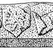
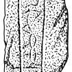
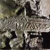
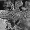
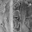
For Pictish symbol stone, cross-slab and cross-incised stones held in the church, see NJ81NE 8.00.
For (present and successor) Dyce Parish Church (NJ 8871 1302), see NJ81SE 47.
(NJ 8752 1540) Church (NAT) (In Ruins)
Formerly Chapel of St Fergus (NR)
OS 6" map (1968)
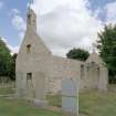
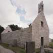
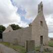
The old church of Dyce was dedicated to St Fergus and dated from pre-Reformation times. Though now ruinous, it was in use until 1872.
J Ritchie 1911
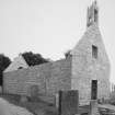
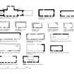
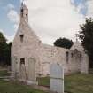
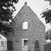
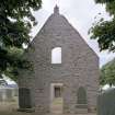
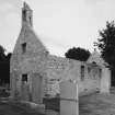
This ruined church, 17.0m by 6.7m, stands to roof level; its walls are 0.8m thick.
Visited by OS (EGC) 20 October 1961
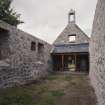
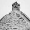
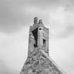
Noted by the SDD as 13th/14th century (?), much altered. It is a long, rubble-built rectangle with a bell-cote, plain splayed Gothic doorways in NW and SW, and remains of a moulded Gothic doorway in the S wall. The square-headed windows are later insertions. (Church, Churchyard Wall, and Watch-house are all Listed: A). (See also NJ81NE 8 for symbol stones etc.)
SDD List 1967
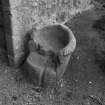
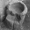
The Ordnance Survey Name Book (ONB) notes a small stone, apparently a font, lying against the W end of the S wall of the church.
Name Book 1870
Nothing potentially Early Christian seen.
A Macdonald and L Laing 1973.
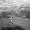
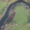
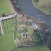
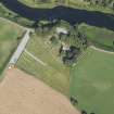
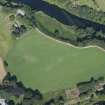
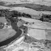
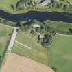
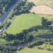
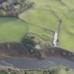
This church is situated on the edge of a river terrace at an altitude of 75m OD.
NMRS, MS/712/78.
Scheduled as Dyce, St Fergus's Church, old parish church and graveyard.
Information from Historic Scotland, scheduling document dated 15 March 2000.
Chapel of St Fergus, Dyce. Old church in passing: AAS/00/03/CT.
NMRS, MS/712/1000.
NMRS REFERENCE:
The ruins of Echt, Old Church were removed in 1966. Information from Demolitions catalogue held in RCAHMS library.
Field Visit (22 November 1996)
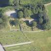
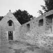
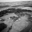
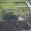
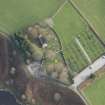
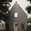
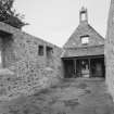
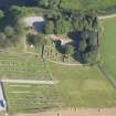
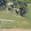
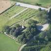
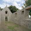
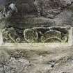
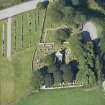
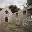
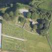
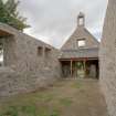
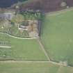
The former parish church of Dyce stands on a promontory in a bend of the River Don and from the north side of the kirkyard the ground falls steeply to the river. The building is a simple rectangle measuring 15.05m from E to W by 4.9m transversely within walls 1m thick. The roofless shell is now heavily shrouded by ivy which renders many of its features invisible but the mortared rubble walls are intact to wall-head height. The interior is presently entered by a doorway in the W gable; a second doorway in the E gable now only serves to provide a view (from outside and through a barred gate) of the Pictish symbol stones and Early Christian crosses built into a shelter against the inner face of the gable. These doors are, however, late insertions and probably of seventeenth or eighteenth century date.
A number of openings, some blocked, can be seen in the interior. Towards the W end of the N wall was a door, now infilled and partly obscured by a commemorative plaque. The relieving arch of this door is visible externally. Approximately mid-way along the wall was a rectangular window and in the corresponding position towards the W end of the S wall was another door. The broadly chamfered jambs of this, and also its arch, can be seen externally. Further to the E in the S wall two large rectangular windows, internally splayed, were the main sources of illumination for the building. Between these was a smaller rectangular window, possibly placed to light the pulpit. Above the door in the W gable is a rectangular window. The E gable contains a similar window, but here it is a later insertion into the original large, pointed-arched, internally splayed window.
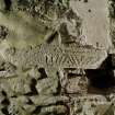
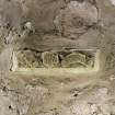
Towards the E end of the N wall is a stone that stands proud of the wall and bears in low relief a shield charged with a lion rampant, between two inscribed scrolls. The edges of the stone are boldly chamfered, the carving is heavily weathered and the inscriptions are illegible. However, from its position in the church and its character, it is believed to be the sill of a sacrament house.
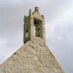
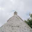
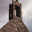
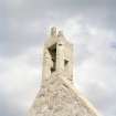
A watercolour (c.1818-20) by James Logan records the church shortly before its closure (Cruickshank 1941, 68-73). This shows the building roofed in slate with a ridge coping. The W gable window and the three windows in the S wall were all in use. Over the door in the W doorway four small panes of glass offered additional illumination. The arched door in the S wall is shown to have been built up by this date, as had another opening, apparently a window, immediately to the E and below the small window in that wall. Surmounting the W gable was a birdcage bellcote of seventeenth-century appearance, with four corner and a tall central finial. Two other sketches record the gabled finial atop the E gable, at that time mounting a small iron cross, and the NW skewputt, which bore a low relief carving of an animal’s head. The bellcote, finial and skewputt are all at present concealed by the ivy. The bell, made in 1642 by Michael Burgerhuys, was removed to the later parish church. It was destroyed when that church was demolished some time after the Second World War (Eeles and Clouston 1959, 157).
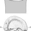
Immediately to the S of the W door of the church stands a massive pink granite block, measuring 0.63m in breadth and 0.6m in height, which is reputed to be the font. Its irregular shape, however, casts doubt upon it having served this role. A bowl 0.47m in diameter and 0.2m in depth has been cut in its upper surface, with a possible drain-hole, 0.15m in diameter, set off-centre in its base. This leads into a groove 0.04m wide by 0.02m deep. The upper portion of the block, containing the bowl, splays externally. Possibly it is a knocking stone.
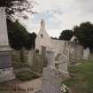
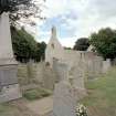
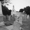
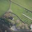
The church stands to the NW of the centre of a subrectangular burial-ground, which is enclosed by a coped rubble and mortar wall. The headstones are mainly of nineteenth and twentieth century date. In the SE corner there is a slate-roofed, rubble and mortar watch-house measuring 4.34m from N to S by 2.34m. It is furnished with a chimney, two windows, now built up, and, in the W wall, a loop-hole. The door is placed in the S gable. An unusual eighteenth century slab has been placed against this gable. The inscription, now lost, has been framed by a pair of pillars and an arch, over which is a double-headed imperial eagle. Below the inscription are the symbols of mortality. This may possibly be the monument of Jean Livingstone (d.1708), the wife of Mr William Ramsay, minister of Dyce (Cruickshank 1941, 72).
Visited by RCAHMS (IFr, AW), 22 November 1996.
Geophysical Survey (28 March 2019)
NJ 87638 15455 On 28 March 2019 a magnetometry survey was carried out in the eastern field adjacent to the Old Parish Church. This was undertaken in order to identify any potential archaeological features or enclosures associated with the church and the collection of Pictish symbol stones. No significant features or structures were found.
Archive: University of Aberdeen
Funder: University of Aberdeen

