
Edinburgh And Dalkeith Railway, Dalkeith Station


Railway Station (19th Century)
Site Name Edinburgh And Dalkeith Railway, Dalkeith Station
Classification Railway Station (19th Century)
Alternative Name(s) Innocent Railway, Formerly Lin 23
Canmore ID 192407
Site Number NT36NW 211
NGR NT 3296 6714
Datum OSGB36 - NGR
Permalink http://canmore.org.uk/site/192407


- Council Midlothian
- Parish Dalkeith
- Former Region Lothian
- Former District Midlothian
- Former County Midlothian
NT36NW 211 3296 6714.
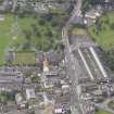
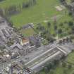
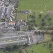
This passenger terminus for the North British Railway was used for more than a century, closing in 1942. The site is now occupied by the local bus station.
A J Mullay 1991.
This site, at the S end of the town, is clearly marked as Railway Station on the 1st edition of the OS 6-inch map (Edinburghshire 1854, sheet 7), and is still visible on the 2nd edition of the OS 6-inch map (Edinburghshire, sheet viiiNE).
The former terminus of the Dalkeith Branch Railway is now overlain by the bus station, which is clearly marked on the OS Basic Scale raster map (ND).
Information from RCAHMS (MD) 26 July 2001.
NMRS REFERENCE
Station opened 12/7/1847
Closed 5/1/1942
Standing Building Recording (October 2011 - April 2012)
NT 3326 6670 - Standing building survey; an enhanced standing building survey was carried out to record the architectural details surviving at the former Eskbank and Dalkeith Railway Station. The station is a two platform through-station built for the North British Railway, and opened on 12 July 1847. Originally known as Eskbank, it was renamed as Eskbank and Dalkeith when the short Dalkeith branchline was closed to passengers in 1942. The station was finally closed in 1969. The station has become overgrown since its closure, but was cleared of its vegetation to allow the building survey to proceed. The principal features recorded include the E and W platform, a ruined building at the N end of the E platform, two sets of stairs leading to the pedestrian footbridge, and a pedestrian platform shelter. Photographs dated to the late 19th century confirmed the presence of an earlier wooden footbridge and a timber built telegraph office. The footbridge was replaced in the 20th century by a riveted cast iron lattice-work footbridge. A small blocked fireplace and brick-built chimney breast are all that survive of the telegraph office. The S end of the E platform has been buried under an earth embankment. The W platform is well preserved along its full length of c166m.
Archive: RCAHMS (intended). Report: East Lothian HER and RCAHMS
Funder: ERM Ltd on behalf of Transport Scotland
Graeme Carruthers, Mike Cressey, Magnus Kirby, Ian Suddaby - CFA Archaeology Ltd, 2013
(Source: DES)

