
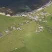
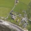
Birsay, Bishop's Palace


Palace (Medieval)
Site Name Birsay, Bishop's Palace
Classification Palace (Medieval)
Canmore ID 1837
Site Number HY22NW 7
NGR HY 2474 2762
Datum OSGB36 - NGR
Permalink http://canmore.org.uk/site/1837


- Council Orkney Islands
- Parish Birsay And Harray
- Former Region Orkney Islands Area
- Former District Orkney
- Former County Orkney
HY22NW 7 2474 2762.
(HY 2474 2762) Bishop's Palace (NR) (Site of)
O S 6" map, Orkney, 2nd ed., (1900).
The date of the transfer of the Bishop's Palace from the Brough of Birsay (HY22NW 1) to the mainland is not known but a 16th c. Bishop dated a letter from 'Mons Bellus' and this inscription, in two pieces and in late-medieval form, is built into the parish church and a neighbouring house.
In 1773 (G Low 1773) the foundations of a 'vast building' were tracable beneath the Minister's and other gardens at Lower Palace, a short distance south of the Earl's Palace (HY22NW 6) (Name Book 1880; Statistical Account [OSA] 1795). The old schoolhouse of Birsay was built upon the site (Name Book 1880). No structural remains are visible (RCAHMS 1946).
'It may be concluded that the later residence of the medieval bishops of Orkney lay on the mainland, on or near the side of the ... palace of Earl Robert Stuart' (HY22NW 6). (C A R Radford 1959).
Name Book 1880; RCAHMS 1946; Statistical Account (OSA) 1795; C A R Radford 1959.
At the published site there is a dilapidated piece of walling, c. 0.6 m. wide, 0.9 m. long and 1.0 m. high, attached to the south wall of the old schoolhouse, reputed locally to be part of the close which led from the Bishop's Palace to the old church (HY22NW 8).
Several old worked stones have been incorporated into neighbouring buildings and people living in the vicinity say that it isimpossible to dig more than a foot below the surface because of the amount of stone in the ground.
The two inscribed stones are as described.
Visited by OS (RL) 25 May 1967.
Project (26 July 2017 - 18 November 2017)
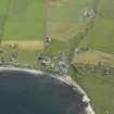
HY 24791 27691 A staged research training and community project was undertaken, 26 July – 18 November 2017, around the story of St Magnus during the 900 commemorative year of his death. Activities including archive research, excavation (25 September – 6 October 2017), walkover survey, geophysical survey, measured survey and coastal survey were primarily focused in and around Palace Village, Birsay. Other key places in the Magnus story were included, such as the site of Magnus’ martyrdom on Egilsay and the Mansie Stane sites where his body was rested during transit. Activities in the village focused on the area within the present house gardens around the site of the medieval Bishop’s Palace (HY22NW 7). Geophysical survey was undertaken in and around Palace Village with three small areas of earth resistance undertaken within residents’ gardens (centred on HY 24749 27607, HY 24730 27617 and HY 24761 27653) and four areas of magnetometry undertaken in surrounding fields (centred on HY 24743 27744, HY 24752 27779, HY 24846 27700 and HY 24863 27755). Little of note was revealed in the results of the resistance surveys relating to the Bishop’s Palace site. Data from the magnetometry surveys has yet to be fully processed, but initial plots show clear linear anomalies (walls?) and other features within the former garden area immediately to the E of the Earl’s Palace (HY22NW 6).
Coastal survey was undertaken around the Point of Buckquoy with the aim of reassessing the sites recorded during the Birsay Bay Project and the numerous NRHE entries (HY 24340 28382 around the point and south to HY 24706 27650). In total, 26 sites were recorded including midden, rubble, stones, structures, nousts, and cut features. These correspond with the numerous prehistoric, medieval and post-medieval features recorded in the Birsay Bay Project coastal survey along the same sections, and will be reported in full in the final report.
Measured plane table survey was undertaken at the boat nousts at Skipi Geo (12 nousts and stone hut, HY 25062 28316) and Point of Buckquoy (13 nousts – HY22NW 45). Scaled plans were drawn.
Walkover survey focused on Palace Village and the area to the E of the Barony Mill. Four sites were recorded including a stone structure in the village (HY 24758 27644), a bridge abutment along the Burn of Boardhouse (HY 25110 27556), the Mans Well (HY22NE 9) and nearby earthwork with stone revetment (HY 25578 27408). The latter is said to be the site of a click mill, although this is unclear from the remains. Previously unrecorded Manse Stane sites, where the body of Magnus was rested when moved, were visited and recorded at Strathyre and along Northside.
A total of eight trenches were excavated within Palace Village, Birsay, and within the gardens of domestic properties in an area which was likely to be that of the earlier and later medieval Bishop’s Palace building (HY22NW 7). Excavation was undertaken by volunteers and undergraduate students under professional supervision.
Trench 1 measured 10 x 2m and was aligned WNW/ESE (HY 24757 27651). A probable flagstone floor and wall was exposed in the base of the trench. Quantities of animal and fish bone and shell were recovered from the stony and midden-type deposit associated with this floor, along with a sherd of Norse/medieval pottery.
Trench 2 measured 3 x 1.5m (HY 24759 27641). Two phases of structural remains were identified. The later structures probably dated to the 19th or early 20th century. The earlier structures appeared to be related to those exposed in Trench A, probably dating to the medieval period. Midden-type deposits were also identified in Trench 2.
Trench 3 measured 2 x 2m, and contained topsoil and windblown sand (HY 24745 27660).
Trench 4 measured 2 x 1.5m (HY 24751 27666). A midden type deposit and a possible robbed out stone-built structural deposit were identified.
Trench 5 measured 2 x 2m, and contained topsoil and windblown sand (HY 24739 27609).
Trench 6 measured 2 x 1m (HY 24742 27619). A midden type deposit, a possible floor surface and wall foundation were exposed in this trench.
Trench A measured 2.9 x 2.7m and was located below the path to the rear of Heimdall (HY 24766 27636). The foundation courses of a substantial stone-built wall, 0.9m wide, with dressed stone faces were exposed. Another, less well preserved wall, 0.75m wide, butted against this on the N side. Midden-type deposits similar to those found in Trench 1, but also containing lime mortar, abutted the base of the walls. The alignment of these structures indicated an earlier phase of construction than the surrounding standing stone-built walls and house, and so could date to the Norse/medieval period, but more likely relates to the 16th-century stables and barns for the Earl’s Palace. Animal and fish bone were recovered from the deposits butting against the main wall.
Trench B measured 1 x 1m, and contained stony topsoil (HY 24772 27633). The main wall exposed in Trench A did not apparently continue to this side of the present house. A layer of windblown sand encountered in all the trenches except Trench B, and was seen to seal the medieval deposits where these were present. In Trench A, the sand was found below the wall and midden. This layer of sand was significantly thicker in those trenches located W of the current boundary wall W of Trench 1. This suggests that the western edge of the medieval settlement was further to the E than in later periods, and that there may have been a short period of abandonment in this area of the settlement in the later medieval period. Excavations confirmed the presence of medieval activity, which may have related to the medieval ecclesiastical complex around the Bishop’s Palace, clustered in the eastern part of the present-day village. Full post-excavation work, finds analysis and radiocarbon dating are pending.
Archive: UHI (currently) and NRHE and Orkney Museum (intended)
Client: Orkney Islands Council. Funding: Heritage Lottery Fund
Daniel Lee, Sarah Jane Gibbon and Sean Bell – Archaeology Institute, UHI
(Source: DES, Volume 18)
Magnetometry (26 July 2017 - 18 November 2017)
HY 24791 27691 Four areas of magnetometry were undertaken in surrounding fields (centred on HY 24743 27744, HY 24752 27779, HY 24846 27700 and HY 24863 27755). Data from the magnetometry surveys has yet to be fully processed, but initial plots show clear linear anomalies (walls?) and other features within the former garden area immediately to the E of the Earl’s Palace (HY22NW 6).
Archive: UHI (currently) and NRHE and Orkney Museum (intended)
Client: Orkney Islands Council. Funding: Heritage Lottery Fund
Daniel Lee, Sarah Jane Gibbon and Sean Bell – Archaeology Institute, UHI
(Source: DES, Volume 18)
Resistivity (26 July 2017 - 18 November 2017)
HY 24791 27691 Three small areas of earth resistance were undertaken within residents’ gardens (centred on HY 24749 27607, HY 24730 27617 and HY 24761 27653). Little of note was revealed in the results of the resistance surveys relating to the Bishop’s Palace site.
Archive: UHI (currently) and NRHE and Orkney Museum (intended)
Client: Orkney Islands Council. Funding: Heritage Lottery Fund
Daniel Lee, Sarah Jane Gibbon and Sean Bell – Archaeology Institute, UHI
(Source: DES, Volume 18)

