
River North Esk


Building (Period Unassigned), Enclosure (Period Unassigned), Farmstead (Period Unassigned), Quarry (Period Unassigned), Sheepfold (Period Unassigned)
Site Name River North Esk
Classification Building (Period Unassigned), Enclosure (Period Unassigned), Farmstead (Period Unassigned), Quarry (Period Unassigned), Sheepfold (Period Unassigned)
Alternative Name(s) Cock Rig End
Canmore ID 181489
Site Number NT15NW 7
NGR NT 1490 5867
Datum OSGB36 - NGR
Permalink http://canmore.org.uk/site/181489


- Council Midlothian
- Parish Penicuik (Midlothian)
- Former Region Lothian
- Former District Midlothian
- Former County Midlothian
NT15NW 7 1490 5867
"The ruin of a dwelling house on the farm of Spittal.."
Name Book 1853-8
An unroofed building and an enclosure marked by pecked lines are depicted on the 1st edition of the OS 6-inch map (Edinburghshire 1853-8, sheet xvii), but they are not shown on the current edition of the OS 1:10560 map (1968).
Information from RCAHMS (SAH) 17 October 2000.
Field Visit (January 1983 - December 1983)
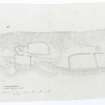
Measured survey compiled by members of the Midlothian Field Group (SH DR RC GW JM ).
Field Visit (June 2010 - September 2011)
Photographs by Julian Hall, a member of the Friends of the Pentlands and and historical research by SRP Pentland Hills.
Srp Note (30 September 2011)
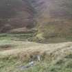
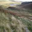
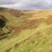
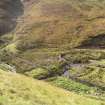
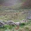
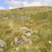
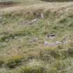
The remains of Cockrigend farmhouse are situated at about 375m OD on a narrow terrace at the SW end of Cock Rig on the E side of the River North Esk and about 500m NW from the northernmost point of the North Esk Reservoir. The site comprises a large sheepfold and a series of low grass-covered rubble mounds forming several conjoined enclosures. None of these appear to define a building, but the 1st Edition of the OS 6-inch map (Edinburghshire 1853-8, sheet xvii) depicts it as a ruined building with attached enclosure and the associated Name Book describes it as the ruin of a dwelling house on the farm of Spittal. Roy’s Military Survey of Scotland, 1747-55, shows a site called “Cock Rigghouse” at exactly the same place that “Cockrigend” is shown. The site does not feature on any modern maps and is not recorded in either the 1841 or 1851 census and since only very slight traces of it are visible on the ground it was probably never a large structure. No other historical information has yet been found for the site.
This site was not visited by the SRP Pentland Hills group during the present project but was identified and surveyed by the Midlothian Field Group (Stratford Halliday, Diana Murray, Robin Callendar, Jane Murray) in 1983 while they were compiling a gazetteer of sites. In the event this particular site was never published so with their permission it has been incorporated into the current SRP Pentland Hills project. Both the site and sheepfold were photographed by Julian Hall, a member of the Friends of the Pentlands who kindly offered his services.
Information from SRP Pentland Hills, September 2011.

