
Flotta, Roan Head


Building (First World War), Building (Second World War), Hut(S) (Second World War), Hut(S) (First World War), Jetty (Second World War), Jetty (First World War)
Site Name Flotta, Roan Head
Classification Building (First World War), Building (Second World War), Hut(S) (Second World War), Hut(S) (First World War), Jetty (Second World War), Jetty (First World War)
Alternative Name(s) Calf Sound; Golta Peninsula; St Vincent Pier
Canmore ID 173787
Site Number ND39NE 13
NGR ND 3788 9618
NGR Description Centred ND 3788 9618
Datum OSGB36 - NGR
Permalink http://canmore.org.uk/site/173787


- Council Orkney Islands
- Parish Walls And Flotta
- Former Region Orkney Islands Area
- Former District Orkney
- Former County Orkney
ND39NE 13 centred 3788 9618
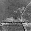
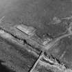
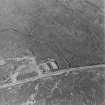
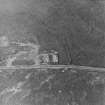
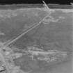
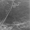
The concrete bases of at least three buildings which are visible on oblique aerial photographs (RCAHMSAP 1997) are situated at the S end of the jetty in Calf Sound on the N shore of Roan Head. In addition, there are the bases of at least a further two huts some 80m upslope from the S of the end of the jetty. All these are structures are of either World War I or World War II construction. In the angle made by the track and the shore line, immediately S of the largest building is a barrage balloon mooring site (ND39NE 14).
Information from RCAHMS (DE), November 2000.
Field Visit (August 1997)
(i) Two rectangular depressions have been cut into the ground surface at the coast edge. Each 'pit' measures 6m by 5m and is up to 1.5m deep. (ii) A series of ruinous reinforced concrete piers, the last vestiges of a jetty, extend from the foreshore into the sea for over 20m. (iii) The concrete and brick footings of a rectangular building, aligned E-W, measure 34m by 8m. The concrete floor is badly slumped and under floor piping is exposed. (iv) A concrete plinth, measuring 2m by 1m is located to S of (ii). (v) A structure with a concrete floor (raised on brick foundations) measures 9m by 3m. To the W of this structure an area of disturbed ground appears to have been previously paved or surfaced. (vii) A metalled trackway leads uphill from the stone jetty in the direction of the military camp at Golta. (viii) A stone jetty, 1.75m wide, extends into the sea for 50m.
Moore and Wilson, 1997
Coastal Zone Assessment Survey
Project (March 2013 - September 2013)
A project to characterise the quantity and quality of the Scottish resource of known surviving remains of the First World War. Carried out in partnership between Historic Scotland and RCAHMS.

