
Halls


Enclosure (Period Unassigned)(Possible)
Site Name Halls
Classification Enclosure (Period Unassigned)(Possible)
Canmore ID 168090
Site Number NT67SE 32
NGR NT 65652 73053
Datum OSGB36 - NGR
Permalink http://canmore.org.uk/site/168090


- Council East Lothian
- Parish Spott (East Lothian)
- Former Region Lothian
- Former District East Lothian
- Former County East Lothian
NT67SE 32 NT 65652 73053
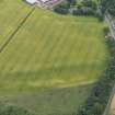
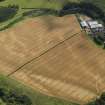
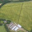
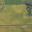
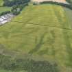
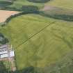
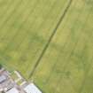
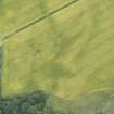
A small roughly circular enclosure has been recorded on oblique aerial photographs (RCAHMSAP 1996) lying on the broad flat terrace to the NE of Halls. It may have measured abou 15m across within a ditch about 2m in breadth.
Information from RCAHMS (DCC) 5 August 2005
Aerial Photographic Transcription (17 July 2019)
An interpretative transcription, or mapping, of information on oblique aerial photographs was produced on 17 July 2019.

