
Doune Of Invernochty


Building (Period Unassigned), Castle (12th Century), Church (Period Unassigned), Kiln (Period Unassigned), Motte (12th Century), Observation Post (20th Century)
Site Name Doune Of Invernochty
Classification Building (Period Unassigned), Castle (12th Century), Church (Period Unassigned), Kiln (Period Unassigned), Motte (12th Century), Observation Post (20th Century)
Canmore ID 16762
Site Number NJ31SE 1
NGR NJ 35151 12957
Datum OSGB36 - NGR
Permalink http://canmore.org.uk/site/16762


- Council Aberdeenshire
- Parish Strathdon
- Former Region Grampian
- Former District Gordon
- Former County Aberdeenshire
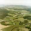
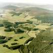
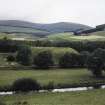
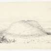
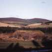
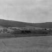
The footings of the original kirk are still visible on the crown of the great earthen castle mound opposite; the Doune of Invernochty, 12th century (60ft high, 250ft x 129ft). Gigantic motte or castle mound, surrounded by a rare system of dams and sluices. Water, from River Bardoch, remained in system as late as 1823.
Taken from "Aberdeenshire: Donside and Strathbogie - An Illustrated Architectural Guide", by Ian Shepherd, 2006. Published by the Rutland Press http://www.rias.org.uk

NJ31SE 1 35151 12957
(NJ 351 129) Doun of Invernochty (NR)
OS 6" map, Aberdeenshire, 2nd ed., (1903)
Excavations were carried out on this monument in 1854.
Building Chronicle, 21 Aug 1854.
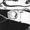
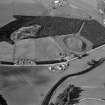
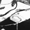
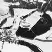
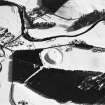
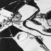
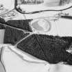
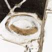
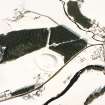
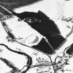
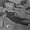
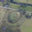
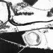
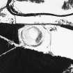
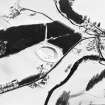
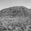
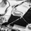
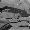
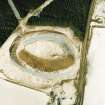
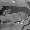
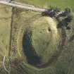
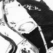
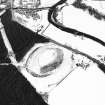
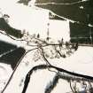
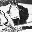
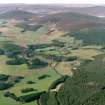
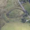
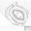
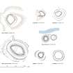
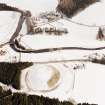
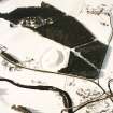
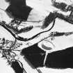
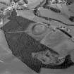
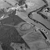
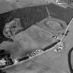
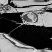
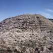
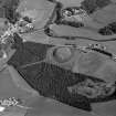
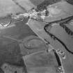
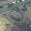
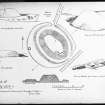
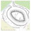
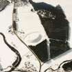
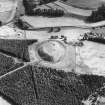
The Doune of Invernochty comprises a motte and earthworks dating from the late 12th/early 13th century. It ranks as one of the finest examples of Norman earthwork castles in Scotland, and appears to be the sole Scottish example of a motte with Norman stonework on its summit. The oval motte is carved out of a glacial mound, about 60ft high, and is surrounded by a ditch 22-32ft wide and averaging 20ft deep. A countersweep bank is enlarged on the W to form a crescentic platform, 74ft at its widest, which is probably a bailey. Jervise (A Jervise 1875-9) states that the remains of several buildings are visible here. A narrow bank around the counterscarp, is probably a palisade bank. A large bank extending from the motte ot the N and W has retained a small lake to supply the ditch with water. It was drained in 1823. Excavations in 1855 by Alexander Walker revealed the piling of a drawbridge and a building supposed to have been a gatehouse further excavated in 1935 by the owner, F L Wallace, revealed a stone curtain wall around the summit of the motte, with an original entrance in the S. Another gap in the N is modern. Of the stone buildings exposed within, one extending across th summit of the motte is almost certainly a large Norman chapel, identified by the discovery of a Norman stoup immediately to the N of it. This is known to have served as the parish church of Invernochty, disused before 1654. Finds included a gold brooch of about 1300, now preserved at Newe; 14th century potsherds, iron work and animal bones.
Name Book 1867; A Jervise 1875-9; W D Simpson 1919; W D Simpson 1936; W D Simpson 1943.
The Doune of Invernochty as described and illustrated by Simpson.
Re-surveyed at 1/2500.
Visited by OS (N K B) 29 August 1968.
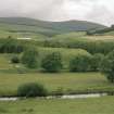
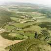
This castle is situated in an area of grazing land at an altitude of 290m OD.
[GRC/AAS ground plans cited].
NMRS, MS/712/43, visited March 1976, 25 May 1989 and 15 August 1995.
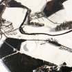
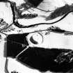
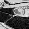
This large and impressive motte probably has a natural mound at its core, although a great deal of earth-moving and sculpting was undoubtedly involved in its construction. It stands to a height of up to 12m above the bottom of the encircling ditch and its roughly oval summit measures 80m from NNW to SSE by 40m transversely. Around the edge of the summit are the low, grass-grown remains of a curtain wall, which, on the S, has been exposed by excavation to reveal a mortared stone wall 2m thick. Immediately to the NW of the exposed wall excavation has also revealed a deeply set rectangular chamber measuring 6m from NW to SE by 4.6m transversely internally. An area of disturbance immediately to the NE of the chamber, including a metal post set in concrete, represents the remains of a Second World War observation post. A large rectangular building straddles the summit and cuts off the northernmost third of the interior from the rest. The building is defined by little more than stone footings and the edges of old excavation trenches dug to follow its walls, but it measures 30m from NE to SW by 11.3m transversely overall. Access to the summit was probably originally gained on the S, where a modern path ascends the motte, whilst a break in the curtain wall at the NW apex is probably modern.
The ditch is some 15m broad and 3m deep, but the low bank that can be traced along its outer lip, is clearly later in date, overlying a broad terrace of made ground that surrounds most of the site. The only gaps in this terrace are on the S, where it may have been destroyed by the road, and on the N. The purpose of this feature is unclear; it is broader (up to 25m) and more regular on the W, but narrower (up to 12m) on the E, where it has a curious wavy outer edge that appears to represent a series of contiguous soil dumps. On the W it is overlain by structures that probably post-date the occupation of the site. These include at least one rectangular building measuring 11.8m from E to W by 4.7m transversely over a low bank, a kiln and an enclosure, and there are also several indeterminate features.
The ditch was formerly water-filled, the water entering through the break in the terrace on the N from an artificially created lake, now drained and planted with conifers. The lake was created by the construction of a dam, 11m thick and about 2m high, which ran NE from the E side of the break in the terrace for a distance of 150m, capturing at least one burn and certainly flooding the area to the N and NE of the motte.
Visited RCAHMS (PC, SPH, KM), 2-6 March 1998.
NJ 3524 1305 A small watching brief was undertaken in June 2004 during the removal of tree stumps for landscaping to provide a new footpath. The site lies adjacent to the Scheduled motte of Doune of Invernochty (NJ31SE 1).
The only archaeological feature noted was a stretch of walling of rough boulders of unknown date. Most of the area was heavily disturbed by the previous forestry plantation.
Full report lodged with Aberdeenshire SMR and the NMRS.
Sponsor: Scottish Woodlands Ltd.
K Cooper 2004.
Publication Account (1986)
This is a massive Norman castle earthwork, the 'capital messuage' of Strathdon, one of the feudal lordships of the province of Mar. Carved out of a glacial mound, the motte is oval in plan and measures an enormous 76m by 36.6m and 18.3m in height. It is surrounded by a ditch and bank. Only two other Norman earthworks are of comparable size, the Motte of Urr in Kirkcudbrightshire and Duffus castle in Moray (no. 32).
The scale (1.8m thick) and mortaring of the curtain wall around the summit suggest that it is a genuine military work rather than a late dyke as at Lumphanan (no. 33). The oblong building whose foundations stretch right across the summit may have been a chapel, in view of the rare carved piscina or stoup fragment found close by; this building may have served as the parish church ofInvernochty until later medieval times. The square foundations near the entrance on the south side of the summit may have been a tower.
The motte is surrounded by a broad ditch which could be flooded from a lake immediately to the west, whose eastern retaining bank can still be seen running through the trees. This, and the sluices that controlled the water at the north-west and east of the counterscarp, represent an important and rare example of early military engineering.
Information from ‘Exploring Scotland’s Heritage: Grampian’, (1986).
Publication Account (1996)
This is a massive Norman castle earthwork, the 'capital messuage' of Strathdon, one of the feudal lordships of the province of Mar. Carved out of a glacial mound, the motte is oval in plan and measures an enormous 76m by 36.6m and 18.3m in height. It is surrounded by a ditch and bank. Only two other Norman earthworks are of comparable Size, the lVlotte of Urr In Kirkcudbrightshire and Duffus castle in Moray (no. 32).
The scale (1.8m thick) and mortaring of the curtain wall around the summit suggest that it is a genuine military work rather than a late dyke as at Lumphanan (no. 33). The oblong building whose foundations stretch right across the summit may have been a chapel, in view of the rare carved piscina or stoup fragment found close by; this building may have served as the parish church of Invernochty until later medieval times. The square foundations near the entrance on the sourh side of the summit may have been a tower.
The motte is surrounded by a broad ditch which could be flooded from a lake immediately to the west, whose eastern retaining bank can still be seen running through the trees. This, and the sluices that controlled the water at the north-west and east of the counter-scarp, represent an important and rare example of early military engineering.
Information from ‘Exploring Scotland’s Heritage: Aberdeen and North-East Scotland’, (1996).

