|
Photographs and Off-line Digital Images |
D 20623 |
RCAHMS Aerial Photography |
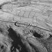
Oblique aerial view of Kirk Hill centred on the remains of a fort and palisaded enclosure with buildings, enclosures, lazy-beds, quarries and a farmstead, field-system, rig and boundary bank adjacent, taken from the WNW. |
1/12/1997 |
Item Level |
|
 |
On-line Digital Images |
SC 371170 |
RCAHMS Aerial Photography |
Oblique aerial view of Kirk Hill centred on the remains of a fort and palisaded enclosure with buildings, enclosures, lazy-beds, quarries and a farmstead, field-system, rig and boundary bank adjacent, taken from the WNW. |
1/12/1997 |
Item Level |
|
 |
On-line Digital Images |
SC 393110 |
RCAHMS Aerial Photography |
Oblique aerial view. |
1/12/1997 |
Item Level |
|
|
Photographs and Off-line Digital Images |
D 24615 CN |
RCAHMS Aerial Photography |
Oblique general aerial view of Ettleton Sike centred on the burial-ground, taken from the E. |
1/12/1997 |
Item Level |
|
|
Manuscripts |
MS 731/20 |
Records of the Royal Commission on the Ancient and Historical Monuments of Scotland (RCAHMS), Edinbu |
Afforestable Land Survey field database (Liddesdale survey, 1996). Held as attribute table in GIS and in Oracle Field/AP table. Please see DX001442 |
1996 |
Item Level |
|
|
Photographs and Off-line Digital Images |
D 20622 |
RCAHMS Aerial Photography |
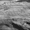
Oblique aerial view of Kirk Hill centred on the remains of a fort and palisaded enclosure with buildings, enclosures, lazy-beds, quarries and a farmstead, field-system, rig and boundary bank adjacent, taken from the NW. |
1/12/1997 |
Item Level |
|
|
Photographs and Off-line Digital Images |
D 20624 |
RCAHMS Aerial Photography |
Oblique aerial view of Kirk Hill centred on the remains of a fort and palisaded enclosure with buildings, enclosures, lazy-beds, quarries and a farmstead, field-system, rig and boundary banks adjacent, taken from the W. |
1/12/1997 |
Item Level |
|
|
Photographs and Off-line Digital Images |
D 20625 |
RCAHMS Aerial Photography |
Oblique aerial view of Kirk Hill centred on the remains of a fort and palisaded enclosure with buildings, enclosures, lazy-beds, quarries and a farmstead, field-system, rig and boundary banks adjacent, taken from the SW. |
1/12/1997 |
Item Level |
|
|
Photographs and Off-line Digital Images |
D 20626 |
RCAHMS Aerial Photography |
Oblique aerial view of Side centred on the remains of boundary ditches, farmstead, sheep stell, field-system, rig and lazy beds with a farmstead, field-system, rig and boundary banks adjacent, taken from the SW. |
1/12/1997 |
Item Level |
|
|
Photographs and Off-line Digital Images |
D 20627 |
RCAHMS Aerial Photography |
Oblique aerial view of Side centred on the remains of boundary ditches, farmstead, sheep stell, field-system, rig and lazy beds with a farmstead, field-system, rig and boundary banks adjacent and a fort and palisaded enclosure in the background, taken from the S. |
1/12/1997 |
Item Level |
|
|
Photographs and Off-line Digital Images |
D 20628 |
RCAHMS Aerial Photography |
Oblique aerial view of Kirk Hill centred on the remains of a fort and palisaded enclosure with a farmstead, field-system, rig and boundary banks and buildings, enclosures, lazy-beds and quarries adjacent, taken from the E. |
1/12/1997 |
Item Level |
|
|
Photographs and Off-line Digital Images |
D 20629 |
RCAHMS Aerial Photography |
Oblique aerial view of Kirk Hill centred on the remains of a fort and palisaded enclosure with a farmstead, field-system, rig and boundary banks and buildings, enclosures, lazy-beds and quarries adjacent, taken from the E. |
1/12/1997 |
Item Level |
|
|
Photographs and Off-line Digital Images |
D 20630 |
RCAHMS Aerial Photography |
Oblique aerial view of Kirk Hill centred on the remains of a fort and palisaded enclosure with a farmstead, field-system, rig and boundary banks and buildings, enclosures, lazy-beds and quarries adjacent, taken from the N. |
1/12/1997 |
Item Level |
|
|
Photographs and Off-line Digital Images |
D 20631 |
RCAHMS Aerial Photography |
Oblique aerial view of Kirk Hill centred on the remains of a fort and palisaded enclosure with a farmstead, field-system, rig and boundary banks and buildings, enclosures, lazy-beds and quarries adjacent, taken from the NW. |
1/12/1997 |
Item Level |
|
|
Photographs and Off-line Digital Images |
D 20632 |
RCAHMS Aerial Photography |
Oblique aerial view of Kirk Hill centred on the remains of a fort and palisaded enclosure with a farmstead, field-system, rig and boundary banks and buildings, enclosures, lazy-beds and quarries adjacent, taken from the W. |
1/12/1997 |
Item Level |
|
|
Photographs and Off-line Digital Images |
D 20633 |
RCAHMS Aerial Photography |
Oblique aerial view of Kirk Hill centred on the remains of a fort and palisaded enclosure with a farmstead, field-system, rig and boundary banks and buildings, enclosures, lazy-beds and quarries adjacent, taken from the SW. |
1/12/1997 |
Item Level |
|
|
Photographs and Off-line Digital Images |
D 20634 |
RCAHMS Aerial Photography |
Oblique aerial view of Ettleton Sike centred on the remains of a farmstead, field-system, rig and boundary banks with further rig and boundary banks adjacent, taken from the NW. |
1/12/1997 |
Item Level |
|
|
Photographs and Off-line Digital Images |
D 20635 |
RCAHMS Aerial Photography |
Oblique aerial view of Ettleton Sike centred on the remains of a farmstead, field-system, rig and boundary banks with further rig and boundary banks adjacent, taken from the WNW. |
1/12/1997 |
Item Level |
|
|
Photographs and Off-line Digital Images |
D 20636 |
RCAHMS Aerial Photography |
Oblique aerial view of Ettleton Sike centred on the remains of a farmstead, field-system, rig and boundary banks with further rig and boundary banks adjacent, taken from the SE. |
1/12/1997 |
Item Level |
|
|
Photographs and Off-line Digital Images |
D 20637 |
RCAHMS Aerial Photography |
Oblique aerial view of Ettleton Sike centred on the remains of a farmstead, field-system, rig and boundary banks with further rig and boundary banks adjacent, taken from the ESE. |
1/12/1997 |
Item Level |
|
|
Photographs and Off-line Digital Images |
D 20638 |
RCAHMS Aerial Photography |
Oblique aerial view of Ettleton Sike centred on the remains of a farmstead, field-system, rig and boundary banks with further rig and boundary banks adjacent, taken from the ENE. |
1/12/1997 |
Item Level |
|
|
Photographs and Off-line Digital Images |
D 20639 |
RCAHMS Aerial Photography |
Oblique aerial view of Ettleton Sike centred on the remains of a farmstead, field-system, rig and boundary banks with further rig and boundary banks adjacent, taken from the NE. |
1/12/1997 |
Item Level |
|
|
Photographs and Off-line Digital Images |
D 24597 CN |
RCAHMS Aerial Photography |
Oblique aerial view of Kirk Hill centred on the remains of a fort and palisaded enclosure with the remains of a farmstead, field-system, rig and boundary banks adjacent, taken from the W. |
1/12/1997 |
Item Level |
|
|
Photographs and Off-line Digital Images |
D 24598 CN |
RCAHMS Aerial Photography |
Oblique aerial view of Kirk Hill centred on the remains of a fort and palisaded enclosure with the remains of buildings, enclosures, lazy-beds, quarries, a farmstead, field-system, rig and boundary banks adjacent, taken from the E. |
1/12/1997 |
Item Level |
|


