
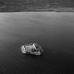
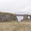
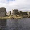
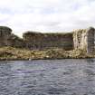
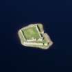
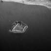
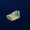
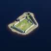
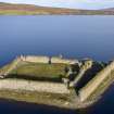
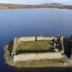
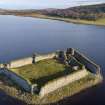
Lochindorb Castle


Castle (Medieval), Human Remains (Period Unassigned)
Site Name Lochindorb Castle
Classification Castle (Medieval), Human Remains (Period Unassigned)
Canmore ID 15463
Site Number NH93NE 1
NGR NH 9745 3632
Datum OSGB36 - NGR
Permalink http://canmore.org.uk/site/15463


First 100 images shown. See the Collections panel (below) for a link to all digital images.
- Council Highland
- Parish Cromdale, Inverallan And Advie
- Former Region Highland
- Former District Badenoch And Strathspey
- Former County Morayshire
NH93NE 1 9745 3632
(NH 9745 3532 ) Lochindorb Castle (NR) (In Ruins)
Human Remains found AD 1866 (NAT)
OS 6" map, Inverness-shire, 2nd ed., (1900)
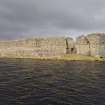
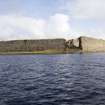
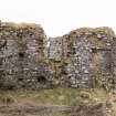
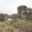
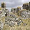
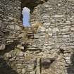
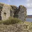
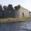
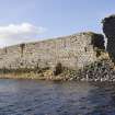
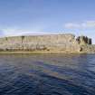
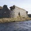
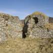
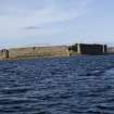
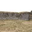
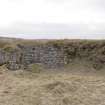
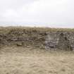
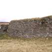
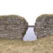
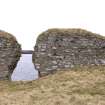
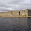
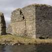
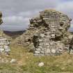
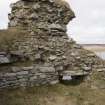
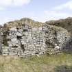
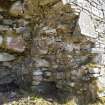
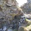
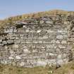
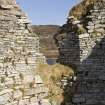
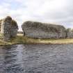
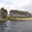
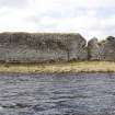
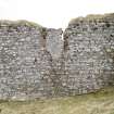
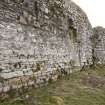
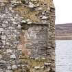
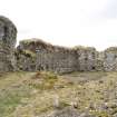
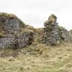
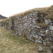
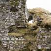
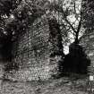
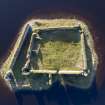
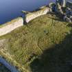
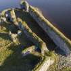
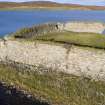
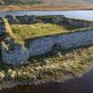
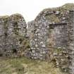
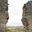
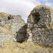
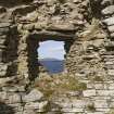
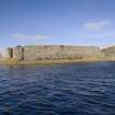
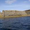
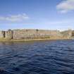
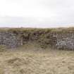
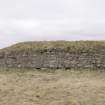
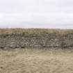
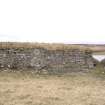
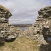
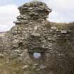
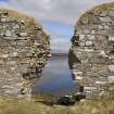
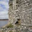
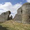
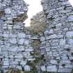
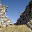
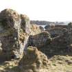
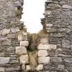
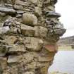
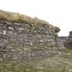
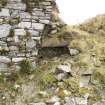
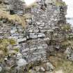
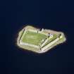
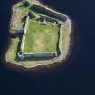
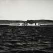
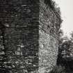
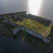
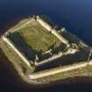
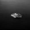
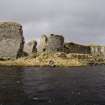
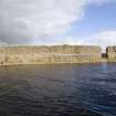
Substantial remains of a 13th century island castle of enceinte comprising a large quadrilateral curtained enclosure with angles strengthened by round towers of comparatively slight projection. No special arrangments appear to have been made for the defence of the entrance gateway, which is centrally placed in the east wall and gives access to a landing stage on the loch shore.
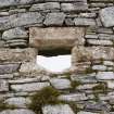
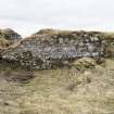
A peculiarity of the site is a forewall on the south possibly a 14th century basse-court addition, with its own port-cullis gateway but with no access to the inner court.
Traces of a range of buildings along with south wall of the main enclosure are still discernable, and the most westerly is known as 'The Chapel'.
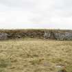
Lochindorb was a stronghold of the Comyns Lords of Badenoch and was captured by Edward I in 1303 and again by his son, who strengthened it, a few years later. From 1372 it was occupied by 'The Wolf of Badenoch', Alexander Stewart, Earl of Buchan, who died in 1394 [1405 has also been suggested as his date of death]. It was ordered, by royal mandate, to be destroyed in 1458, having been fortified against the king, but the walls still stand to almost full height.
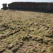
The Statistical Account (OSA, 1793) quotes local opinion as saying that the castle is built on an artifical island - apparently confirmed by the appearance of great rafts, or planks of oak, by the beating of the water against the old walls.
Ordnance Survey name book (ONB, 1871) gives no further information on the human remains found in 1866.
OSA 1793; Name Book 1871; D MacGibbon and T Ross 1887-92; J G Dunbar 1966.
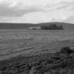
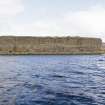
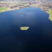
(Lochindorb Castle, 10.4km NW of Grantown-on-Spey). Island stronghold in the loch of the same name.
The castle is first recorded during the Wars of Independence when Sir John ('the Black') Comyn died there in 1300. By 1455 the castle was in the hands of Archibald Douglas, Earl of Moray, The next year, after Douglas's defeat and death at Arkinholm, Lochindorb was again forfeited to the Crown and this time ordered to be slighted, the work of dismantling its defences being entrusted to the Thane of Cawdor. Since then, it has been left as a ruin.
J Gifford 1992.
The 1974 edition of the OS 1:10,000 map notes the winter water level of Lochindorb as being at an altitude of 295m above Newlyn datum in 1965.
Information from RCAHMS (RJCM), 7 October 1998.
Non-Guardianship Sites Plan Collection, DC28211, 1936.
Underwater Archaeology (August 1993)
In August 1993 the Scottish Trust for Underwater Archaeology (STUA) carried out preliminary underwater investigation in the area around the castle following the discovery of artefacts and the recognition of structures during diving by Mr K McComiskie and others. The loch reaches a maximum depth of about 17m, has an average depth of 4m, and is shallower than this over about half its area.
Underwater survey around the main island suggested that the mound may have been artificially constructed before the construction of the castle, no bedrock being apparent either on the island or in the surrounding waters. On the W side of the island, the underwater profile is a gentle slope which gradually merges with the loch bed. Many of the stones that make up the mound appear to have been artificially deposited, but their wide range in size and type may point to a natural origin. On the S and E sides, the mound has far more of an artificial appearance, the angle of slope being steeper and the stones more homogenous, as has been noted around artificial islands in Loch Tay.
The submerged area to the N of the island displays features (specifically, fallen walls) which are clearly man-made, but is otherwise more like the W side than the S and E. The loch bed slopes away gently on this side, layers of natural clay being apparent.
The walls off the N side of the island were planned and drawn. Their date, function and origin remain uncertain but they may incorporate the remains of one of the curtain walls that were demolished in 1458 or, alternatively, represent another feature, specifically a landing-stage or small harbour or the robbed remains of a pre-castle structure. A large oak beam was found projecting from the loch bed near the submerged walls and may be one of those noted in the Old Statistical Account. The suggested existence of an earlier crannog cannot be substantiated.
Clearly-defined ridges of sand and gravel were observed between the island and the E shore of the loch and initially thought to be the remains of a causeway or similar structure; their situation at a minimum depth of 3m underwater makes this improbable and they display little evidence of artificial construction. They are thus assumed to be of natural, presumably glacial, origin.
Two stone balls were found during examination of these features and another three later. They measure between 0.24 and 0.28m in diameter, are apparently of granite and were all found between 25 and 30m from the shore. They were most probably fired as stone shot from a trebuchet during Sir Andrew Murray's siege of 1335.
A trench 1m square was laid out and a small area within this excavated off the NE corner of the island in an area from which Mr McComiskie lifted a large storage jar in 1992. Within the loose silt that had fallen into the hole since the removal of the pot, there were found small pieces of wood (some with cut-marks), a few fragments of burnt peat, and other comminuted burnt material. The stratigraphic sequence was found to comprise fine, mobile silt (context 001) overlying a slightly thicker and more sticky sediment (context 002) which contained weeds and appeared to have been naturally deposited. A fragment of a pot-handle was also found but left in situ. Beneath context 002 there was a layer (context 003) which is characterised by black specks, pieces of charcoal, burnt peat and fragments of cut wood and appears to represent a period of habitation. By contrast, context 001 is evidently transitory, mobile and, therefore, modern while context 002 (which measures about 50mm in thickness) is related to related to a period of occupation of the island. Context 003, therefore, must represent either an earlier phase of castle occupation or the occupation of the island before the construction of the castle.
The jar that was recovered in 1992 is believed to be contemporary with the 15th century occupation of the castle, and is displayed in Inverness Museum. The four fragments of handle found nearby are different from it, and need not be chronologically related.
A few planks and a knee from a small boat were found in shallow water to the E of the island; they were not deeply embedded in the loch bottom and may be associated with the second layer of sticky silt noted in the trench, or may be associated with the pottery fragments. The significance of fragments of bone and a perforated stone found in no clear association (the latter off the SE side of the island) remains unclear.
The demonstration (or otherwise) of pre-castle occupation remains the major topic of interest, the following proposals for further study being made accordingly:
1. examination and radiocarbon dating of timber fragments from contexts 002 and 003
2. bathymetric and remote sensing (sonar/sub-bottom profiling) survey of the loch
3. detailed study of the submerged forest and peat bank at the S end of the loch
4. excavation of the area around the fallen walls and oak beam to establish their relationship with the castle
5. excavation of [random] areas of the loch-bed, of the area around the finds and across one or more of the ridges.
NMRS, MS/974/4.
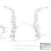
Measured Survey (August 2009 - April 2010)
At the request of Historic Scotland, a measured survey of Lochindorb Castle was carried out by RCAHMS during 2009-10. The aim was to prepare phased plans of the site, profiles and a photographic record in order to provide a basis for the management of the site. In addition to refining the overall plan of the site and the two main phases of later 13th and 14th century dates respectively, four grassed-covered buildings were recorded in the courtyard and evidence was found for a primary hall and chamber range along the W curtain of the castle. Many parallels with the Comyn castle of Inverlochy were noted.
Visited by RCAHMS (PJD, IA, JB and HS) April 2010
Mortar Analysis
NH 9745 3632 A programme of landscape, buildings and materials analysis is being carried out at Lochindorb Castle within the framework of this project. Buildings analysis at Lochindorb Castle highlighted that the three main surviving upstanding structures on the site – the Primary Enclosure, Outer works and East Range – display large volumes of exposed constructional mortars in various continuous core to bedding contexts. In situ examination suggested that each of these structures were bound with wood-fired limestone-lime mortars of varying textures, and a sampling programme was subsequently undertaken to enable further lab-based analysis of selected materials. The sample assemblage removed and collected included 13 relict fuel inclusions, 3 core mortar fragments, 1 relict limestone clast, 1 loose sandstone fragment, and 1 sample of loch-side sand.
Lab-based analysis of the assemblage included microscopic thick and thin section analysis of all mortar and limestone samples. This confirmed that each of the three main upstanding structures were bound with wood-fired limestone-lime mortars, but also highlighted evidence for various compositional contrasts in temper grades and/or limestone sources. This evidence suggests that the three main castle structures under investigation are likely to be associated with three different constructional events, and that the S end of the E Range is not coeval with either of the other two main phases. The relict fuel assemblage from the E Range and Primary Enclosure was taxonomically consistent and eight samples from these structures were subsequently selected for radiocarbon analysis.
Archive: NRHE (intended)
Funder: University of Stirling and Historic Environment Scotland
Mark Thacker – University of Stirling
(Source: DES Vol 19)

