
Jura, Keils, General


Village (19th Century)
Site Name Jura, Keils, General
Classification Village (19th Century)
Alternative Name(s) Kiells; Kilearnadill
Canmore ID 152684
Site Number NR56NW 41
NGR NR 5255 6830
NGR Description Centred NR 5255 6830
Datum OSGB36 - NGR
Permalink http://canmore.org.uk/site/152684


- Council Argyll And Bute
- Parish Jura
- Former Region Strathclyde
- Former District Argyll And Bute
- Former County Argyll
NR56NW 41.00 centred 5255 6830
NR56NW 41.01 NR 52555 68294 Byre
NR56NW 41.02 NR 5257 6829 Stackyard
NR56NW 41.03 NR 52583 68294 Farmhouse
NR56NW 41.04 NR 52536 68285 Byre
NR56NW 41.05 NR 52492 68314 House
NR56NW 41.06 NR 54536 68338 Cottage
See also NR56NW 21.00.
Field Visit (May 1981)
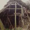
NR 525 683. The small crofting settlement of Keils, formerly the township of Kilearnadill (Argyll Valuation Roll, 1751 (SRO, E 106/ 3/2)), retains several thatched buildings, now ruinous or used as outbuildings in connection with modern dwellings. They include a substantial single-storeyed dwelling with gable chimneys, and other gable-ended dwellings of earlier type, as well as byres and a small pigsty. Three of the buildings preserve remains of cruck-framed roof-structures. One of these comprises only a single scarf-jointed cruck-couple, while another incorporates three substantial couples carried on stone pads some 0.7 m above floor-level.
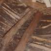
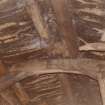
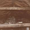
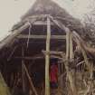
The most interesting building [Canmore ID 152686] lies in the S part of the township, immediately W of a yard which contains about a dozen circular cobbled stack-stances [152687]. It was probably constructed originally as a byre-dwelling, and remained in use as a byre until the partial collapse of its roof following the wet winter of 1980-1 (the accompanying drawings and description were prepared in 1974, by courtesy of M r A Black, Keils). It measures 14.5m from E to W by 5.5m transversely over drystone walls averaging 0.8m in thickness, formed of rounded boulders probably derived from the glacial drift-deposits, with larger roughly quarried blocks in the quoins. The lower or E end appears to have been reconstructed; the masonry of its gable is more neatly coursed than that of the remainder of the building, and its roof is carried on rafters springing from the wall-head. The upper end, or dwelling, measured about 6.5m in internal length and was divided into three bays by cruck-couples, while the fourth bay contained opposed entrance-doorways. The only windows were two small openings in the S wall, and a blocked recess whose timber lintel survives in the inner face of the W gable was probably an aumbry. The position of the original hearth is uncertain, since the floor has been altered to provide a drainage-channel, but a boarded smoke-vent supported on the ridge-purlins survives in the thatch above the second bay. While most of the existing stall-divisions are of timber, they include some large slabs of slate.
The lower members of each of the three extant cruck-couples are substantial squared timbers of pine, rising from pad-stones about 0.5m above present floor-level, and scarf-jointed with wooden pegs to the unsquared upper blades, which are separated by lap-jointed yokes and lower collars (the unsquared collar of the third couple (which collapsed in 1981) was a replacement, and the recesses for the original lap-jointed collar survived at a lower level). Short subsidiary rafters rising from the wall-head supported the lower of a series of purlins, some of which were held in place by heather rope. These in turn carried small rafters below a layer of turf which appears to have been covered originally with heather, but subsequently with rushes and straw.
RCAHMS 1984, visited May 1981.
Publication Account (1985)
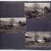
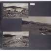
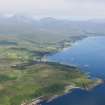
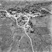
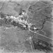
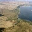
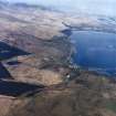
The little crofting township ofKeils on Jura may be taken as a typical example of the smaller settlement unit in many parts of the west Highlands. The air photograph shows the layout of the houses, byres and barns. The stackyard illustrates the type of stone foundation for small haystacks that was once common in Argyll; the interior of the byre, now sadly dilapidated, shows the method of construction of the cruck-framed roof-the crucks springing from the wall with the supporting cross-timbers near the ridge. The drain, however, is not original, and there is little doubt that this byre was built as a longhouse comparable to those at Auchindrain, partly as a dwelling and partly as a stalled byre. The air photograph also illustrates the strip system that operated in the open fields at Keils.
Information from ‘Exploring Scotland’s Heritage: Argyll and the Western Isles’, (1985).
Standing Building Recording (4 July 2017 - 5 July 2017)
NR 52555 68306 A walkover survey, Level 1 building survey and an evaluation were undertaken, 4–5 July 2017, in advance of the conservation and rebuilding of structures at Keils. No significant features or deposits other than the upstanding ruins (including a partially rebuilt dwelling) were discovered.
Archive: NRHE (intended)
Funder: Private individual
Clare Ellis – Argyll Archaeology
(Source: DES, Volume 18)

