
Isle Of Noss, Nesti Voe


Burial Ground (Early Medieval), Chapel (Medieval), Composite Slab Shrine (Early Medieval), Cross Slab (Early Medieval), Grave Slab(S) (17th Century), Rune Inscribed Stone (Norse)
Site Name Isle Of Noss, Nesti Voe
Classification Burial Ground (Early Medieval), Chapel (Medieval), Composite Slab Shrine (Early Medieval), Cross Slab (Early Medieval), Grave Slab(S) (17th Century), Rune Inscribed Stone (Norse)
Alternative Name(s) Gungstie
Canmore ID 1291
Site Number HU54SW 9
NGR HU 5307 4094
Datum OSGB36 - NGR
Permalink http://canmore.org.uk/site/1291


- Council Shetland Islands
- Parish Bressay
- Former Region Shetland Islands Area
- Former District Shetland
- Former County Shetland
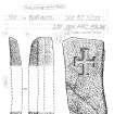
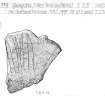
Gungstie 1, Noss, Shetland, portable cross-slab fragment
Measurements: H 0.24m, W 0.10m
Stone type: sandstone
Place of discovery: HU 5307 4094
Present location: Shetland Museum, Lerwick (ARC 66116).
Evidence for discovery: found in 1959 lying at the edge of the graveyard.
Present condition: the top left and bottom right corners are broken away.
Description
This small portable slab is incised with an equal-armed cross, the side arms of which extend to the sides of the slab. The arms terminate in rectangular boxes, and there is a central square box, and the arms have a median line or inner cross.
Date: seventh or eighth century.
References: Scott & Ritchie 2009, 32, 51, no 67.
Compiled by A Ritchie 2016
Gungstie 3, Noss, Shetland, rune-inscribed fragment
Measurements: H 0.25m, W 0.23m
Stone type: sandstone
Place of discovery: HU 5307 4094
Present location: Shetland Museum, Lerwick (ARC 1995.88).
Evidence for discovery: found in the graveyard during excavations in 1994.
Present condition: none of the edges is intact and the carved surface is worn.
Description
This fragment is roughly incised with four elongated rune-like figures and a possible cross.
Date: uncertain.
References: Barnes & Page 2006, 7; Scott & Ritchie 2009, 35, no 78.
Compiled by A Ritchie 2016
Gungstie 4, Noss, Shetland, cross-slab
Measurements: H 0.68m, W 0.27m
Stone type: sandstone
Place of discovery: HU 5307 4094
Present location: Shetland Museum, Lerwick (ARC 1996.205).
Evidence for discovery: found in the graveyard in 1996.
Present condition: good.
Description
This slab tapers towards the base and is carved on one broad face with a sunken cross with barred terminals.
Date: seventh century.
References: Fisher 2002, 54-5; Scott & Ritchie 2009, 31, no 63.
Compiled by A Ritchie 2016
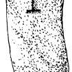
Gungstie 2, Noss, Shetland, shrine post
Measurements: H 1.32m, W at upper dressed portion 0.15m, D 0.16m
Stone type: sandstone
Place of discovery: HU 5307 4094
Present location: Shetland Museum, Lerwick (ARC 1994.726).
Evidence for discovery: found at the north end of the graveyard in 1994.
Present condition: good.
Description
A long beach boulder was selected to make this corner post, for which purpose the upper part was dressed to an almost square section, and longitudinal grooves were carved in three faces to take the side-panels of a composite slab-shrine. The presence of three grooves indicates that this was a double shrine.
Date: seventh or eighth century.
References: Scott & Ritchie 2009, 24-5, no 46.
Desk-based information compiled by A Ritchie 2016
HU54SW 9 5307 4094.
(HU 5305 4095) Chapel (GT) (Site of): Burial Ground (GT)
OS 6" map, Shetland, 2nd ed., (1902).
Though extant in 1711 the chapel, of unknown date or dedication, was ruined by 1841, and the burial ground disused by 1878.
R Sibbald 1711; New Statistical Account (NSA) 1845; Name Book 1878.
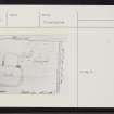
Planned in 1852 the chapel, of unknown dedication, consisted of a nave and chancel, of which only a fragment of the N wall of the chancel remained, about 4 or 5ft high. The nave was about 18ft 6 ins by 14ft, and the chancel about 12ft E to W, by 10ft N to S, shown by a ridge in the turf.
D MacGibbon and T Ross 1896.
There are no remains of the building but there are two 17th century grave-slabs in the graveyard.
RCAHMS 1946, visited 9th July 1930.
A broken cross-slab, incised with a very early form of interlaced cross, was found at the edge of the graveyard on the Isle of Noss, Bressay, by Mrs E J Smith, Keldagarth, Geoster, Bigton, in 1959, and is now in the Shetland Museum (accession no. : ARC 66116).
Acc Reg Shetland Museum.
The walls of the church show as barely definable swellings in the turf, through which protrude an occasional stone and one or two fragments of wall-footing. Overall, the nave measures 28ft N-S by 25ft E-W and the chancel 18ft N-S by 17ft E-W. The graveyard, apparently unenclosed, on the S side of the church, stretches east to the edge of the cliff - a number of stones have fallen over, down the slope. The two 17th century stones are still visible.
A MacDonald (MOPBW), MS
The poor turf-covered remains of a chapel as described and planned by MacDonald. Disused graveyard as described.
Visited by OS (NKB) 18th May 1968.
HU 5310 4095. Coastal erosion has begun to affect the scheduled graveyard in Noss, on the E side of the peninsula on which the graveyard is situated. Erosion has been particularly severe at the point where a drainage pipe had been cut through, a few years ago. The cutting of the pipe trench was not supervised archaeologically, and can now be seen to have disturbed at least three skeletons at the cliff edge. These three were partially excavated in May 1993, before they were lost to the sea. Work stopped at the point at which the cliff became more stable.
The upper torso of the southern skeleton was exposed. The right side of the pelvis and legs had already been lost. The skull faced to its left, face up against a stone slab set on edge. There was no sign of a coffin or other wrapping visible.
The left upper leg, a fragment of the pelvis, the lower arms and the lower spine of the middle skeleton were excavated and removed. The pelvis and part of the upper right femur of the northern skeleton were also excavated. Neither of these bodies could be shown to have been laid in a coffin or wrapping.
At the N end of the site, on the edge of the bank, lies a slotted stone, likely to be a corner-post for a stone-slab structure (perhaps a corner-post shrine. It was left in situ. Cliff erosion is continuing.
Sponsor: Historic Scotland
V Turner 1993
HU 530 409 A small trench, 10m long and up to 2m, was opened up on the top of eroding cliffs on the E side of the Gungstie peninsula. The area comprised part of the scheduled chapel and graveyard site. The intention was to remove the human remains which were beginning to erode into the sea, priorto carrying out coastal protection work below the scheduled area. The protection works were carried out in conjunction with Scottish Natural Heritage and the Scottish Conservation Volunteers.
A possible corner post from an Early Christian shrine was thought (supra) to be lying in this area: excavation verified that this was what the stone was, and sets the date of the site back to the 8th century. The corner post was found not to be lying in its original setting and no further pieces of the shrine were found within the small area opened up. A broken rune stone suggests continued use of the site during the Viking period, The area had been intensively used and reused for burial: some of the burials had been in coffins, others definitely had not been. One skeleton was found lying across what appears to be part of the foundation and facing stones of a possible round tower of a 12th-century chapel, similar in size to the one which still stands on Egilsay, Orkney. (Three such towers are known in Shetland from documentary evidence.) If the chapel shared the same orientation as that in Egilsay, the rest of it will have already fallen into the sea.
Sponsors: Historic Scotland (coastal protection sponsored by Shetland Amenity Trust, Scottish Natural Heritage, Scottish Conservation Volunteers).
V Turner 1994.
HU 530 409 Rectangular grey sandstone slab with broad, deeply incised cross. From Early Christian church at Noss, where an altar corner post was found in 1994 (NMRS HU54SW 9).
T Watt and I Tait 1996
HU 530 409 In 1999 Scottish Natural Heritage opened up a small access/service sondage to a sewage pipe which had been inserted across the Scheduled area in 1985. A small number of human remains were recovered. Scheduled Monument Consent was granted for a manhole cover to be inserted. A watching brief, carried out in August 1999, identified that the sondage merely cut through earlier, disturbed and redeposited material, resulting from the initial construction of the sewage pipe.
Sponsors: Shetland Amenity Trust, Scottish Natural Heritage.
V Turner and B Simpson 1999
Field Visit (9 July 1930)
Chapel and burial-ground, Noss (Site). The site of this chapel is close to the shepherd's cottage at the landing place on the island of Noss. There are no remains of the building, but two 17th century grave-slabs mark the position of the graveyard. The inscriptions are illegible, but each of the stones has borne a heraldic shield and the usual emblems of mortality.
RCAHMS 1946 No. 1110, visited 9 July 1930.

