
Dingwall, Castle Street, Dingwall Castle


Castle (Medieval), Motte (Medieval)(Possible)
Site Name Dingwall, Castle Street, Dingwall Castle
Classification Castle (Medieval), Motte (Medieval)(Possible)
Alternative Name(s) Mote Of Dingwall; Dingwall, The Castle House
Canmore ID 12774
Site Number NH55NE 4
NGR NH 55318 58999
Datum OSGB36 - NGR
Permalink http://canmore.org.uk/site/12774


- Council Highland
- Parish Dingwall
- Former Region Highland
- Former District Ross And Cromarty
- Former County Ross And Cromarty
NH55NE 4.00 5532 5901
NH55NE 4.01 NH 55269 58939 dovecot
NH55NE 4.02 NH 5531 5902 monument to Roderick Maclennan
For the Castle House, in the grounds of which Dinwall Castle ruins lie, see
NH55NE 54 NH 55336 59026
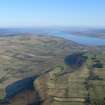
(NH 5532 5899) Castle in ruins. Depicted as being on an isolated mound about 100 feet overall diameter, and about 40 feet diameter across the top.
Town plan of Dingwall,(scale 39 1/2 ins to 1 mile)
J Wood 1821.
Castle (Remains of) (A.T.)
OS 25" map, Ross-shire, 1st ed., (1876)
The Castle was surrounded by a deep ditch.
OSA 1792.
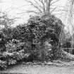
The remains of Dingwall Castle consist of one narrow underground vault and two masses of masonry above ground.
D MacGibbon and T Ross 1892.
The castle site was levelled in 1818. One of the corner towers of the Castle was transformed into a dovecot by Andrew, Bishop of Caithness, a keeper of the castle between 1507-16 A.D. and is still exists as one of the ruined fragments.
N Macrae 1923.
Dingwall Castle is referred to as the 'Mote of Dingwall' in 1488.
W Mc MacKenzie 1927.
Dingwall Castle is marked on a 12/13th century map in the Bodleian Library.
D MacDonald, A Polson and J Brown 1931.
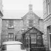
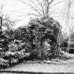
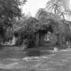
The remains of this castle are situated in a private garden at NH 5532 5901 and consist of a small circular tower c.3.4 m. in diameter, standing to a height of 2.6 m., with walls 0.5 m. thick. Attached to the northeast side of the tower is a large block of masonry 3.2 m. wide and standing to a height of c.3.0 m, and on the north-west side of the tower project the remains of a wall c.1.5 m. long, c.7.0 m. to the west of the tower is a large mass of masonry covered with ivy, probably the remains of a wall. This stands to a height of c.3.0 m. but no other measurements could be taken with any degree of certainty. C.10.0 m. to the south-west of the tower is the entrance to a small underground barrel vault, measuring 5.0 m. in length, by 1.8 m. wide and 1.7 m. high. At a distance of c.2.0 m. back from the south enclosing garden wall the ground slopes down gently towards the wall forming a shallow ditch with a maximum depth of c.1.0 m. about 5.0 m. from the wall. This ditch, which looks the result of landscape gardening, extends from the east side of the carriage drive for a distance of c.8.0 m. before fading out, and the owner, Col. John W. Stevenson, believes it to indicate the course of the ditch which formerly surrounded the castle. The remainder of the garden is level with no indication of a motte. The dovecot is at NH 5526 5893. It is an octagonal unroofed tower of red sandstone c.3.7 m. diameter with walls 0.6 m. thick. It was probably of two storeys with a parapet top but thick ivy now obscures the top of the tower. Its present height is c.4 m. The ground floor has gun loops in three of the south facing sides, a fireplace and a doorway in the east side. A number of stone pigeon boxes have been built in to the sides of the building. The dovecot is probably later than the other remains.
Published Survey (25" 1904) to be amended by field surveyor.
Visited by OS (W D J) 17 April 1963.
(Location cited as NH 471 588). Motte noted at Dingwall.
P A Yeoman 1988.
Castle / motte - eroded, poor state - turfed mound left; houses built on top.
CFA/MORA Coastal Assessment Survey 1998.
Field Visit (September 1979)
Dingwall Castle NH 553 590 NH55NE 4
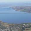
This castle, which comes on record in the 13th century, was levelled in 1818 and the site is now occupied by a house of that period. The existing remains comprise part of a ditch, a small vaulted chamber and a length of rubble-built wall 1. 7m thick to which a circular garden pavilion has been added in the 19th century.
RCAHMS 1979, visited September 1978
(MacGibbon and Ross 1887-92, iv, 390; Macrae 1923, 49-77)
Publication Account (1982)
The exact age of the castle of Dingwall is unknown, although along with Dumbarton Castle it was one of two Scottish royal strongholds marked on Matthew Paris' map of 1259 (MacDonald, n.d., 47). It was first held for the crown by the Mormaer of Ross and in 1291 it was held by William of Braytoft who delivered the fortress to John Baliol on Edward l's orders. After the reconciliation of Robert I with William, fourth earl of Ross, Dingwall Castle became the seat of that family until their forfeiture in 1476 (MacDonald, n.d.,47). James IV on a number of visits to Tain stayed in Dingwall Castle and the crown continued to appoint keepers until 1584 when James VI granted it to Sir Andrew Keith who was subsequently created Lord Dingwall (MacDonald, n.d.,47). By 180ls the castle was in ruins and the present castle was erected in 1820 by a naval man who had served in the Napoleonic wars (MacDonald, n.d.,49).
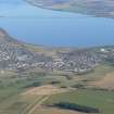
Only fragmentary remains survive of the royal castle of Dingwall in the grounds of the present castle which was largely erected on the site of the former. The castle stood close to the shore on about half an acre of ground and was surrounded by water except along the line of the present Castle Street. A fosse which surrounded it could be traced as late as 1841 (NSA, 1841, 221). The remains of the royal castle primarily consist of one narrow underground vault and two masses of masonry above ground. One of the corner towers was converted into a dovecot by Andrew, Bishop of Caithness, keeper of the castle between 1507-1526 a.d. and still exists as one of the ruined fragments (Ordnance Survey, Record Cards, NH 55 NE 4).
Information from ‘Historic Dingwall: The Archaeological Implications of Development’ (1982).

