
Preston Mains


Pit(S) (Period Unassigned)(Possible), Rig And Furrow (Medieval) - (Post Medieval), Ring Ditch (Period Unassigned)(Possible), Track (Period Unassigned)
Site Name Preston Mains
Classification Pit(S) (Period Unassigned)(Possible), Rig And Furrow (Medieval) - (Post Medieval), Ring Ditch (Period Unassigned)(Possible), Track (Period Unassigned)
Canmore ID 125062
Site Number NT57NE 94
NGR NT 59929 78398
NGR Description From NT 5991 7830 to NT 5992 7851
Datum OSGB36 - NGR
Permalink http://canmore.org.uk/site/125062


- Council East Lothian
- Parish Prestonkirk
- Former Region Lothian
- Former District East Lothian
- Former County East Lothian
NT57NE 94 5991 7830 to 5992 7851
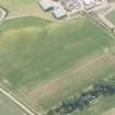
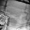
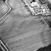
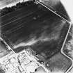
Aerial photographs (RCAHMSAP 1994) have recorded a double linear cropmark running N-S for approximately 200m, in a field E and adjacent to Preston Mains (NT57NE 50). A possible ring-ditch situated roughly half way along the linear cropmark has also been recorded.
Information from (JH) 2 June 1998.
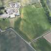
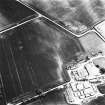
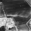
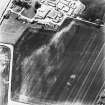
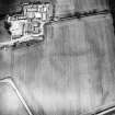
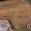
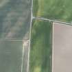
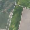
A trackway, a possible ring-ditch, several blocks of rig and a scatter of possible pits have been recorded as cropmarks on oblique aerial photographs (RCAHMSAP 1994, 1996) on the crest and sides of a low ridge in the field immediately to the NE of Preston Mains farmsteading.
The trackway is defined by parallel ditches set about 5m apart, which extend for about 200m from N to S (NT 59919 78287 - NT 59914 78483) but with a slight alteration in its axis on the crest of the ridge. On the crest of the ridge, immediately to the E of the trackway, there is also an arc of ditch describing a shallow C-shape (NT 59933 78424), which is open to the E, but may continue to form a roughly circular ring-ditch measuring about 7m in internal diameter. The blocks of rigs lie to the N (NT 59921 78524) and E (NT 59992 78424) of the trackway; the furrows are spaced about 5m apart and are aligned roughly NNW and SSE. A scatter of possible pits is suggested by a slight mottling in the crop across parts of the field.
Information from RCAHMS (DCC) 3 March 2005

