
Redhouse


Enclosed Settlement (Iron Age)(Possible)
Site Name Redhouse
Classification Enclosed Settlement (Iron Age)(Possible)
Canmore ID 124839
Site Number NT47NE 61
NGR NT 45889 77729
Datum OSGB36 - NGR
Permalink http://canmore.org.uk/site/124839


- Council East Lothian
- Parish Aberlady
- Former Region Lothian
- Former District East Lothian
- Former County East Lothian
Note (28 September 2022)
The location, classification and period of this site have been reviewed.
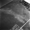
Aerial Photographic Interpretation (28 September 2022)
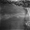
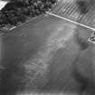
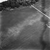
The SE half of what may be an Iron Age enclosed settlement has been recorded as cropmarking on oblique aerial photographs (RCAHMSAP 1994) on level ground about 330m NE of Redhouse Burn. It measures about 55m from NE to SW by about 34m transversely within a ditch about 2m broad. What may be a ring ditch house is visible in the interior. It measures about 10m in diameter within a ditch about 2m broad, broken by an entrance gap on the S.
Information from HES Archaeological Survey (F. Vermeij) 28 September 2022

