
Mill Of Noth


Grain Mill (19th Century), Watermill (19th Century)
Site Name Mill Of Noth
Classification Grain Mill (19th Century), Watermill (19th Century)
Alternative Name(s) Burn Of Eassaiche
Canmore ID 120272
Site Number NJ52NW 51
NGR NJ 50216 27740
Datum OSGB36 - NGR
Permalink http://canmore.org.uk/site/120272


- Council Aberdeenshire
- Parish Rhynie
- Former Region Grampian
- Former District Gordon
- Former County Aberdeenshire
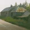
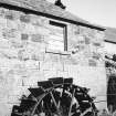
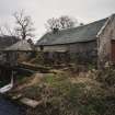
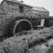
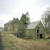
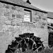
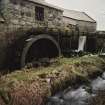
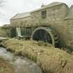
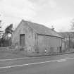
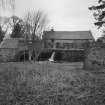
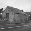
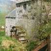
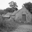
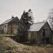
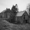
Mill of Noth, late 18th/early 19th century (1835). On Burn of Eassaiche, a harled rubble group, two-storey-and-attic with an 11ft 8in diameter start-and-awe wheel and kiln with small revolving ventilator. Later additions.
Taken from "Aberdeenshire: Donside and Strathbogie - An Illustrated Architectural Guide", by Ian Shepherd, 2006. Published by the Rutland Press http://www.rias.org.uk

NJ52NW 51 50216 27740
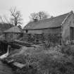
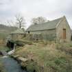
(Location cited as NJ 502 278). A 2-storey and attic rubble building, partly harled. The central kiln has a small square ventilator with a revolving cap. At the rear is an 8-spoke, mid-breast, wood and iron paddlewheel, 2ft 11ins (0.89m) wide by 11ft 8ins (3.55m) diameter.
J R Hume 1977.
Partly harled: disused.
Surveyed by SIAS.
NMRS, MS/712/52.
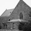
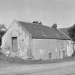
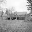
A water-powered grain mill with an iron-framed overshot waterwheel and associated flume and lade, but which at the time of survey in 2002 was in an advanced state of decay, sections of roof (over the mill itself) having collapsed. The mill, which is two-storeyed with rubble walls and a piended slate roof, occupied an 'L'-plan building at the north end of the range, the kiln (with revolving roof venitlator) being situated in the centre, sandwiched between the mill and a store at the south end of the range.
Information from RCAHMS
MKO 2002
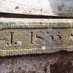
Mainly 2-storey, single-storey and loft, harled rubble. Angled plan with kiln and later additions, 11' dia. double framed start-and-awe wheel. Disused A lintel stone to the back of the building reads 1835. (Historic Scotland)

