
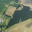
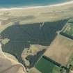
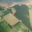
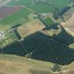
Hedderwick Hill Plantation


Anti Tank Blocks (20th Century), Trench(S) (20th Century)
Site Name Hedderwick Hill Plantation
Classification Anti Tank Blocks (20th Century), Trench(S) (20th Century)
Alternative Name(s) Belhaven Bay
Canmore ID 113956
Site Number NT67NE 158
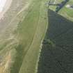
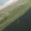
NGR NT 650 789
NGR Description From NT 650 789 to NT 652 787
Datum OSGB36 - NGR
Permalink http://canmore.org.uk/site/113956


- Council East Lothian
- Parish Dunbar
- Former Region Lothian
- Former District East Lothian
- Former County East Lothian
NT67NE 158 650 789 to 652 787
Site recorded during a rapid coastal survey undertaken by GUARD of the S shore of the Firth of Forth from Dunbar to Stirling and along the N shore of the Forth to the Fife border. A gazetteer of all sites including listed buildings, designed landscapes, scheduled and unscheduled monuments was produced. Full details of the survey can be consulted in the report held by the NMRS.
Sponsor: Historic Scotland
GUARD 1996
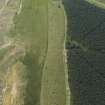
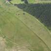
Slit trench system seen on 1946 aerial photographs but not visible on 1988 aerial photographs. B174 4060-61
Site recorded by GUARD during the Coastal Assessment Survey for Historic Scotland, 'The Firth of Forth from Dunbar to the Coast of Fife' 1996.
The trench system is visible on vertical air photographs (RAF 106G/UK 1319, 5065-6, flown 28 March 1946) as two distinct lines set on the coastal side of a double line of anti-tank blocks which run E as far as the Bell Water. The anti-tank blocks continued W round Belhaven Bay. The anti-tank blocks have since been removed.
Information from RCAHMS (DE), October 2002
Field Visit (1996)
Slit trench system seen on 1946 aerial photographs but not visible on 1988 aerial photographs. B174 4060-61
Site recorded by GUARD during the Coastal Assessment Survey for Historic Scotland, 'The Firth of Forth from Dunbar to the Coast of Fife' 1996.

