
Skye, Kraiknish


Dun (Iron Age), Hut(S) (Post Medieval)
Site Name Skye, Kraiknish
Classification Dun (Iron Age), Hut(S) (Post Medieval)
Alternative Name(s) Loch Eynort
Canmore ID 11042
Site Number NG32SE 2
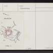
NGR NG 3546 2340
Datum OSGB36 - NGR
Permalink http://canmore.org.uk/site/11042


- Council Highland
- Parish Bracadale
- Former Region Highland
- Former District Skye And Lochalsh
- Former County Inverness-shire
Field Visit (15 May 1915)
Dun, Kraiknish, Loch Eynort.
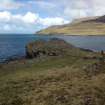
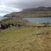
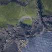
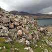
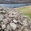
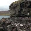
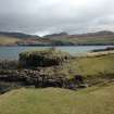
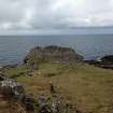
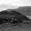
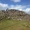
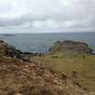
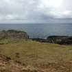
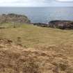
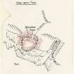
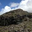
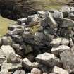
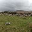
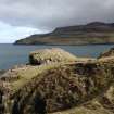
On an elevated rock , rising about 50 feet above the water, on the southern side of the mouth of Loch Eynort, about 1 mile west of Kraiknish, is a ruined dun. On the flanks the rock has a height of about 25 feet, and on the landward side towards the south-east it is about 15 feet high, and is approached by a steep slope. The defences consist of a stone wall built on the edge of the rock, and an outer wall built on the slope towards the land with its ends resting on the rocks on the flanks. The inner wall , enclosing a rounded triangular space, measuring some 56 feet from north-east to south-west, and some 52 feet from north-west to south-east internally, has almost disappeared on the sides next to the sea, but on the landward side it shows the inner face rising about 4 feet above the interior, and the outer face standing to a height of 7 feet on the south, the remaining section being for the greater part hidden by tumbled stones. At its widest part it is 10 feet 9 inches thick, but it attenuates as it curves back and merges into the side walls. The outer face of the outer wall, showing 3 feet of building at most in position, stands 19 feet from, and apparently about 8 feet lower than, the inner wall. The roadway into the dun lies towards the southern end of the outer wall, which recurves inwards at the entrance. The wall on the left side is broken down , but the entrance seems to have been about 4 feet wide. The roadway slants to the left and enters the enceinte through an inner entrance, also broken down, about 4 feet 4 inches in width.
Visited by RCAHMS (JGC) 15 May 1915.
OS Map: Skye xliii (unnoted) .
Desk Based Assessment (12 September 1960)
NG32SE 2 3546 2340.
(NG 3546 2340) Dun (NR).
OS 6"map, Inverness-shire, 2nd ed., (1903)
Dun, Kraiknish, Loch Eynort.
On an elevated rock, rising about 50ft above the water, on the S side of the mouth of Loch Eynort, about 1 mile W of Kraiknish, is a ruined dun. On the flanks the rock has a height of about 25ft, and on the landward side towards the SE it is about 15ft high and is approached by a steep slope. The defences consist of a stone wall built on the edge of the rock, and an outer wall built on the slope towards the land with its ends resting on the rocks on the flanks. The inner wall, enclosing a rounded triangular space, measuring some 56ft NE-SW and some 52ft from NW-SE internally, has almost disappeared on the sides next the sea, but on the landward side it shows an inner face rising about 4ft above the interior, and the outer face standing to a height of 7ft on the S, the remaining section being for the greater part hidden by tumbled stones. At its widest part it is 10ft 9ins thick, but it attenuates as it curves back and merges into the side walls. The outer face of the outer wall, showing 3ft of building at most in position, stands 19ft from, and apparently about 8ft lower than, the inner wall. The roadway into the dun lies towards the S end of the outer wall, which curves inwards at the entrance. The wall on the left side is broken down, but the entrance seems to have been about 4ft wide. The roadway slants to the left and enters the enceinte through an inner entrance, also broken down, about 4ft 4ins wide.
Information from OS (AC) 12 September 1960
Source: RCAHMS 1928.
Field Visit (6 June 1961)
A dun as described by RCAHMS. In poor condition.
Visited by OS (ASP) 6 June 1961.
1/1250 divorced plan on record card.
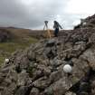
Field Visit (15 May 2013 - 16 May 2013)
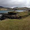
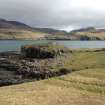
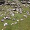
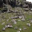
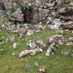
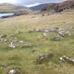
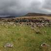
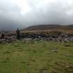
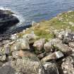
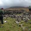
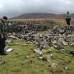
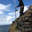
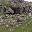
This dun is situated on the S side of the mouth of Loch Eynort, on a narrow coastal promontory that stands some 16m above the sea-level on the W but no more than 4m - 5m on the landward side A rounded triangle on plan, it measures a maximum of 18m from NNE to SSW by 16.6m from E to W within a stone wall up to 3.4m in thickness (but reducing to only 1.6m on the W) which stands to an external height of 2.5m on the SW and an internal height of 1.3m where best preserved. There is an entrance (1.5m wide) on the ESE in which a recently exposed door-check is visible. The interior of the dun is largely featureless. There are the faintest traces of a stony platform which may indicate the site of a structure: the purpose of a wall 2m in length, 1m in thickness and only one course high, which is set close to the dun wall on the S, is not known.
There is an additional line of defence, comprising a wall measuring at least 25m in length and about 3m in thickness, which is set downslope from and no more than about 2.5m - 3m from the inner wall on the landward (ESE) side. The inner face of this wall is completely obscured by rubble but the outer face, which stands up to 1m high, exhibits two phases of construction N of the entrance. Here, two outer wall-faces are visible, demonstrating that the structure has been reduced in thickness by 0.5m. The entrance through this wall measures 1.5m in width and is set slightly further to the N than the corresponding gap in the inner wall.
Evidence of later activity in the vicinity of the dun includes five huts which lie within 30m of it and two small conjoined pens which have been constructed against the outer face of the inner wall a little to the N of the entrance. The largest of the huts (NG 35494 23401) lies immediately E of the dun. Oval on plan, it measures 3.5m from N to S by 3.2m transversely within a low stone wall (0.8m thick) that probably represents the footing of a largely turf-built structure. The NE side of the hut appears to overlie a denuded wall, which defines the SW side of a plot of lazy-bed cultivation that is most probably associated with the nearby township of Laimhrig na Moine (NG32SE 15). A second hut (NG 35504 23403), close-by to the ENE, is set into and is therefore demonstrably later than one of the lazy-beds. The three other huts are situated at NG 35488 23402; NG 35480 23388 and NG 35477 23381 respectively. The prominent stone wall that runs from a point immediately S of the entrance through the outer wall of the dun ESE for a distance of about 33m, where it terminates against a steep rock-face, probably relates to a more recent period of stock control.
The site was surveyed by AOC Archaeology Ltd (15-16 May 2013).
Visited by RCAHMS (GFG) 15-16 May 2013.
Field Visit (15 May 2013 - 16 May 2013)
NG 3546 2340 A survey of Kraiknish Dun was carried out, 15–16 May 2013, using laser scanning. A topographic and photographic survey was also undertaken and plans and orthographic profiles of the site produced at a range of scales.
Archive: RCAHMS
Funder: Forestry Commission Scotland
Graeme Cavers and Gemma Hudson, AOC Archaeology Group, 2013
(Source: DES)

