
Berneray, Cnoc Na Greine


Chambered Cairn (Neolithic)(Possible)
Site Name Berneray, Cnoc Na Greine
Classification Chambered Cairn (Neolithic)(Possible)
Alternative Name(s) Cnoc Na Greana
Canmore ID 10491
Site Number NF98SW 2
NGR NF 92307 81876
Datum OSGB36 - NGR
Permalink http://canmore.org.uk/site/10491


- Council Western Isles
- Parish Harris
- Former Region Western Isles Islands Area
- Former District Western Isles
- Former County Inverness-shire
NF98SW 2 9230 8187.
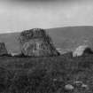
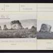
(NF 9230 8187) Possible burial chamber with no signs of a cairn. It stands on a knowe, Cnoc na Greana, about 200 yards NE of the Unitied Free Church.
Only three upright stones and a prostrate stone remain. The largest stone, on the W side, is 5ft 5ins high. Other prone slabs to the N and NW may be detected below the turf. These stones may have been part of a chamber.
The OSA notes the large stone with a circle of stones less than 10ft in diameter 'which surrounds it'; the circle being 'made up of long sharp pointed stones, laid not very close together, but so as a man may pass betwixt every two'.
This is almost certainly the site in which was found a 'human lower jaw and portion of another' donated to the NMAS by Capt F W L Thomas in 1860.
RCAHMS 1928; F W L Thomas 1862; Statistical Account (OSA) 1794; Information contained in MS of A S Henshall's 'Chambered Tombs of Scotland', Vol. 2, 29, No. 18, plan.
The four stones, situated in an area of scattered outcrop rock, are as described above. There is no definite trace of a circle of stones or remains of a cairn.
Surveyed at 1/2500.
Visited by OS (R D) 20 June 1965.
Field Visit (14 August 1914)
Standing Stones (Cnoc na Greana).
On a knowe, Cnoc na Greana ("sun's knowe"), overlooking Bays Loch on the east side of Berneray, about 200 yards north-east of the United Free Church, at an elevation of 100 feet above sea-level, is a large ice-carried boulder with two standing stones and a prostrate stone to the east of it placed so as to form the southern arc of a circle. Two other boulders to the north and north-west may have formed part of the stone setting but they seem to have been dislodged, probably in the formation of the old track which passes between them. Along the eastern continuation of the arc formed by the erect stones is a slight bank of soil. The large boulder, almost pentagonal on plan, is 5 feet high with the sides varying from 3 feet to 4 feet 10 inches in length; the adjoining erect stone 2 feet 5 inches to the east is 3 feet 4 inches high, 2 feet 6 inches across the inner face and 1 foot 7 inches thick at most; the other of rhomboidal plan, 1 foot 6 inches away, is 2 feet 9 inches high and 7 feet in girth, and the prostrate stone, lying 3 feet from the last, is 3 feet 2 inches in length. (Fig. 96.)
RCAHSM 1928, visited 14 August 1914.
OS map: Harris xxvi (unnoted)
Field Visit (18 September 2010)
What are possibly the remains of a chambered cairn are situated on the gentle SE-facing slope overlooking the shore of Bays Loch. All that remains of the chamber are a large erratic block about 1.6m high accompanied on its E by two small upright slabs 0.8m high, which stand on the S side of a shallow scooped out terrace about 5m across. No cairn material is visible, though a slightly rough band of ground about 4m wide swinging around the SW quarter, and a low swelling to the NE of the terrace at the centre may denote its extent, giving an overall diameter of about 14m. As noted by Henshall, the old road running past on the N probably accounts for the robbing.
Visited by RCAHMS (SPH) 18 September 2010

