
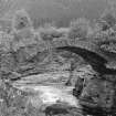
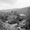
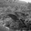
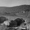
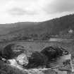
Invermoriston Old Bridge


Road Bridge (Period Unassigned)
Site Name Invermoriston Old Bridge
Classification Road Bridge (Period Unassigned)
Alternative Name(s) River Moriston; Loch Ness
Canmore ID 104504
Site Number NH41NW 11
NGR NH 41954 16572
Datum OSGB36 - NGR
Permalink http://canmore.org.uk/site/104504


- Council Highland
- Parish Boleskine And Abertarff
- Former Region Highland
- Former District Inverness
- Former County Inverness-shire
NH41NW 11.00 NH 41954 16572
NH41NW 11.01 NH 41988 16542 New Bridge (Invermoriston Bridge)
(Location cited as NH 419 166). Old Bridge, Invermoriston, built 1803-21, engineer Thomas Telford. The arch rings, with parts of the spandrels, of a 2-span rubble bridge, by-passed in 1933. The central pier is a rocky islet in the river.
J R Hume 1977.
This bridge carries the former line of the A82 public road across the River Moriston immediately NW of its successor bridge (NH41NW 11.01) and a short distance above the debouchement of the river into Loch Ness. The river here forms the boundary between the parishes of Urquhart and Glenmoriston (to the N) and Boleskine and Abertarff (to the S).
Information from RCAHMS (RJCM), 18 December 2000.

