
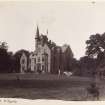
Maxpoffle


House (Post Medieval), House (Medieval)
Site Name Maxpoffle
Classification House (Post Medieval), House (Medieval)
Canmore ID 100046
Site Number NT53SE 115
NGR NT 55832 30356
Datum OSGB36 - NGR
Permalink http://canmore.org.uk/site/100046

- Council Scottish Borders, The
- Parish St Boswells
- Former Region Borders
- Former District Ettrick And Lauderdale
- Former County Roxburghshire
NT53SE 115.00 55832 30356
NT53SE 115.01 55892 30416 Dovecot
NMRS REFERENCE:
Plan and elevation of House of Maxpoffle. Signed by John Smith & W. Scott as that referred to in estimates and specification.
1807 GD 104/262
Sbc Note
Visibility: Evidence for this site, or the origins of this site, comes from documentary sources. Nothing may be visible at this location.
Information from SBC.
Sbc Note
Shown as Morpole on Ponts map.
Information from Scottish Borders Council Historic Environment Record
(n.d.)

